|
||

|

|
|

|
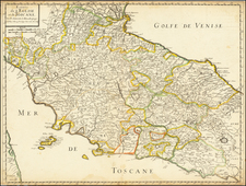
Spanish Siege of Ostia -- Historic Port of Rome
Rare thematic map of the area between the environs of Rome and the harbor at Ostia.
While Lafreri School Battle Plans occasionally show roads, this map is quite exceptional as a regional map which shows both roads and Roman Aqueducts.
The map illustrates the theater of war during the siege of Spanish-held Ostia by General Pietro Strozzi, Superintendent of the Papal army under Pope Paul IV, resulting in the capitulation of the fortress on January 24, 1557. Oriented with east at the top, the map is intended to illustrate the roads, rivers and Roman Aqueducts between Rome and the port of Ostia.
The map shows the medieval walled town of Ostia, nestling against a meander in the Tiber which, later that year, was cut off from the main stream by a flood which crossed the neck of the meander leaving an ox-bow lake which was still present on topographical maps in the late nineteenth century (Arnoldu-Huyzendveld). The rounded walls of the town contrast sharply with the later star-shaped, angle-bastioned trace Italienne forts of the Papal and Imperial forces.
The imperial and papal fortifications are shown, along with their their encampments and the armies lined up for the attack on the fortress of Ostia. The city, besieged by Spanish troops led by Fernando Alvarez de Toledo, Duke of Alba and Viceroy of Naples surrendered on November 18, 1556, but was resumed on January 23, 1557.
The map is drawn from a from the work of Eufrosino della Volpaia, with the addition of information relating to the fortifications at the mouth of the river. The map has been attributed to Antonio Salamanca's printing house and is listed in the catalog of Salamanca's partner, Antonio Lafreri.
States of the map / Rarity
There are two states of the map.
- State 1: 1557 - Antonio Salamanca (dated)
- State 2: 1602 - Giovanni Orlandi name added
- State 3: 1602 - Hendrik van Schoel's name added
All states are extremely rare on the market.
The Lafreri School is a commonly used name for a group of mapmakers, engravers, and publishers who worked in Rome and Venice from ca. 1544 to 1585. The makers, who were loosely connected via business partnerships and collaborations, created maps that were then bound into composite atlases; the maps would be chosen based on the buyer or compiler’s interests. As the maps were initially published as separate-sheets, the style and size of maps included under the umbrella of the “School” differed widely. These differences can also be seen in the surviving Lafreri atlases, which have maps bound in with varying formats including as folded maps, maps with wide, trimmed, or added margins, smaller maps, etc.
The most famous mapmakers of the School included Giacomo Gastaldi and Paolo Forlani, among others. The School’s namesake, Antonio Lafreri, was a map and printseller. His 1572 catalog of his stock, entitled Indice Delle Tavole Moderne Di Geografia Della Maggior Parte Del Mondo, has a similar title to many of the composite atlases and thus his name became associated with the entire output of the larger group.
Antonio Salamanca was a print seller and publisher based in Rome. While he was known by the surname Salamanca, his family name was actually Martinez; he hailed from Salamanca, Spain. His shop was in the Campo de’ Fiori and it served as a gathering place for those with antiquarian interests. Later in his career, he partnered with Antonio Lafreri, the era’ most prominent Italian map publisher. Salamanca’s stock was sold to Lafreri after the former’s death.
![[ Villa Farnese ] Caprarola Arx et Horti Farnesiani](https://storage.googleapis.com/raremaps/img/small/96849.jpg)
![[ Istria / Croatia ] Nouvelle Carte de L'Istrie Suivant le Plan dresse sur les lieux . . .1780](https://storage.googleapis.com/raremaps/img/small/37133.jpg)