|
||

|

|
|

|
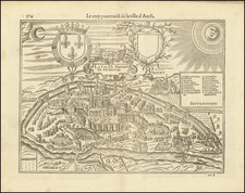
Rare First Map of Limousin
Fine early map of the area around Limoges in southwestern France. This work originally appeared in the very rare text by Maurice Bouguereau, Le Theatre Francoys, known as the first national atlas of France.
Detail on the map is extensive, however, de Dainville notes that this map omits many monasteries and religious establishments, calling it "curiously secular and monarchical," in contrast with the other two original maps which appear in the Theatre. This can possibly be ascribed as an attempt by Fayen to curry political favor, as the King Henry IV was currently at war with the Catholic League when this map was published and had been exiled to Tours.
The map includes an inset of the city of Limoges, showing the city within its old walls and listing places of interest. Also featured on this map is a poem by the late 16th-century poet Joachim Blanchon, a coat of arms, and an extensive description of the region. This map extends from Argenton in the north to the Dordogne region in the south, as far as Perigueux.
Unlike most other maps in Le Theatre Francoys, this map is not copied from any previous work, and, instead, is based on original surveys conducted by Jean Fayen. This is the earliest map of the region.
Le Theatre Francoys
This very rare volume is understood to be the first national atlas of France. Published in Tours during the French king's exile from Paris, this work reunites maps of northern and central France.
Many of the maps in the volume are copied from earlier Ortelius and Mercator sources, although some, particularly in the region around Tours, are original maps. These maps would be reused by later authors, including Hondius, Blaeu, and Jansson. All the maps in the text are engraved by Tavernier.
The volume suffered from a lack of spatial completeness, with much of the south of France lacking any coverage. While Bouguereau put a plea for more maps in his introduction, subsequent, more complete editions of this work would not be published until well into the 17th century. The first complete edition would appear in 1642 under the name Theatre Geographique due Royaume de France.
Melchior Tavernier was a member of a large family involved in the publishing trade in Paris in the early years of the seventeenth century. Early in his career, he apparently collaborated with Henricus Hondius, as at least one of his early maps references Tavernier as the seller of a map engraved in Amsterdam, by Hondius. He is probably best known for his publication of a map of the Post Roads of France, which was copied many times until the end of the century. He also issued an atlas under the same title as J. le Clerc's Theatre Geographique, using many of Le Clerc's maps, but incorporating others from different sources. He published composite atlases and also published works for other cartographers, including N. Sanson, N. Tassin, and P. Bertius. He is not to be confused with his nephew of the same name (1594-1665), who also engraved maps for Nicolas Sanson.
![[Biscaya] De Zeecusten van Vrancrijck en Biscaijen tuschen Arcachon en de C. de Machicaco](https://storage.googleapis.com/raremaps/img/small/84355.jpg)
![[Perpignan]](https://storage.googleapis.com/raremaps/img/small/75063.jpg)