|
||

|

|
|

|
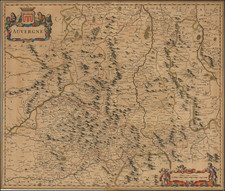
First State of a Lafreri School Map of Piedmont, Attributed to Antonio Lafreri Himself
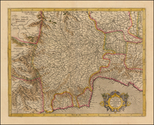
Fantastic map of the Piedmont region in northern Italy, showing magnificent and attractive detail throughout. This map, first published in the middle of the 16th-century, was reprinted several times in the later 16th century, with the 1564 second state signed by Antonio Lafreri. This is the first state of the map and is attributed by Bifolco and Ronca (950) and Tooley to Lafreri based on the typography and style.
The map bears similarities to two other maps, a manuscript map of the region by Battista Agnese, the celebrated portolan-maker, and a less detailed map published by Antonio Salamanca in 1553. The similarities to the Agnese map are visible in both the geography and the design, with the exception of the graduated borders. The Antonia Salamanca map focuses on the same region and takes the same perspective. It is likely that these three maps all share a common source, which Bifolco and Ronca suggest is unknown.
The map shows the northwesternmost part of Italy, from the French border to the Po Valley, in great detail. The Lafreri School style of engraving is particularly notable in the mountains, which are rounded and shaded to give a particular depth of impression. Many cities and towns in the region are named, including Nice, Savona, San Remo, Turin, as well as mountain areas such as the Val de Pot, the Val di Stura, and the Col de la Cros.
In all, a fine early map of the region with particular attention to toponymic detail and an attractive layout.
States
This map is known in four states:
- 1560 circa. Undated.
- 1564. With the imprint: Antonio Lafreri formis Romae 1564
- 1580 circa. With the imprint: Petri de Nobilibus Formis.
- 1589. Erasure of the de Nobili imprint, with remnant a visible as a gap in the stippled sea below the cartouche.
This is the first state of the map, without any additional imprints.
The Lafreri School is a commonly used name for a group of mapmakers, engravers, and publishers who worked in Rome and Venice from ca. 1544 to 1585. The makers, who were loosely connected via business partnerships and collaborations, created maps that were then bound into composite atlases; the maps would be chosen based on the buyer or compiler’s interests. As the maps were initially published as separate-sheets, the style and size of maps included under the umbrella of the “School” differed widely. These differences can also be seen in the surviving Lafreri atlases, which have maps bound in with varying formats including as folded maps, maps with wide, trimmed, or added margins, smaller maps, etc.
The most famous mapmakers of the School included Giacomo Gastaldi and Paolo Forlani, among others. The School’s namesake, Antonio Lafreri, was a map and printseller. His 1572 catalog of his stock, entitled Indice Delle Tavole Moderne Di Geografia Della Maggior Parte Del Mondo, has a similar title to many of the composite atlases and thus his name became associated with the entire output of the larger group.
Antonio Lafreri (1512-1577) (also known as Antoine Lafréry and Antoine du Pérac Lafréry) was a French mapmaker, engraver, and publisher who worked in Italy. Lafreri was born in Franche-Comté and moved to Rome around 1540. Lafreri sold sheet maps but he also bound maps into books for his clients based on their interests and needs. These are the famous Lafreri atlases, important pre-cursors to the modern atlas. He also published well known works such as the Speculum Romanae Magnificentiae (ca. 1575), a collection of engraved views and images of Rome. Lafreri was well-connected to the cartographic networks of the time, collaborating with Giacomo Gastaldi, Battista Agnese, Antonio Salamanca, Donato Bertelli, Paolo Forlani, and others.
![[ Tuscany ] Carte Du Grand-Duche De Toscane . . . 1776](https://storage.googleapis.com/raremaps/img/small/101843.jpg)