


|
||

|

|
|

|
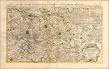
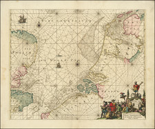
The Earliest Obtainable Example of Gilles Boileau de Buillon's map of Flanders
First state of this early map of the Roman Province of Gallo-Belgica and adjacent regions, published in Rome in 1558.
The map is based upon the 1557 map of Gilles Boileau de Buillon (known in a single example), whose name appears in Ortelius' Catalogus auctorum as a source for his map of Flanders. While them map is anonymous, it is typically attrbiuted to the workshop of Antonio Salamanca.
Oriented with south at the top, The map extends south to Paris, Reins, Verdun, Metz and Nancy, East to Luxembourg and Cologne, and north to Breda, Venlo, Antwerp and Zeeland. Includes a small portion of England, including Dover, Sandwich and Canterbury.
The cartouche at the top left reads:
Habes hic, candide Lector, Galliam belgigam cum suis Regionibus, Opidis, Castellis, fluminibus, ac syluis diligenter expressam: adiectis horum omnium locorum interse distantiis quas easy invenies si perspecta miliarium differentia, super pincta in omnibus descripta circinu [m] aptabis Haec autem descriptio cum ad alia permulta tum ad Comme [n] tariorum Caesaris intellige [n] tiam plurimum conferet, Vale.
Printed in Rome in 1558, the map is without maker, but typically attributed to Antonio Salamanca. The title Gallia Belgica, often used for Belgium and Holland as a whole, has often generated confusion in historical cartography studies. Gallia Belgica (also known as Le Tres Galliae) was an ancient province of the Roman Empire.
The map is a precise copy of the work of Gilles Boileau de Buillon published in Antwerp by Johannes Liefrinck in 1557. The Bouillon map seems to have been compiled to illustrate an edition of the De Bello Gallico (although it survives in a single copy); showing several toponyms in Latin and some Roman roads that connect the various cities.
This map was highly influential and was copied by several Italian printers. The present map, published the following year in 1558, is attributed to the printing house of Antonio Salamanca. Like the original, it maintains the orientation with the south at the top; even the graphic scales are the same many of the placenames have remained in Flemish.
Stefano Bifolco confirms that this should be the work of Salamanca, as the plate is, in fact, included in the catalog of the Lafreri printing house (no. 60), inventoried as “Gallia Belgica”, which was inherited by Stefano Duchetti (inv. 1581, n. 86, as "Belgian galia") and sold by him to Paolo Graziani (inv. 1583, n. 336), finally appearing in the catalog of Pietro de Nobili (inv. 1585, n. 324, as "Pezo reale la gallia belgica") who reissues the map with his own editorial imprint; the only known example of this edition is in the National Library of Malta.
The first and anonymous map of the region is directly derived form Gilles Boileau de Buillon's map of Flanders, with north and south reversed, which was printed the year before. Listed in Ortelius' Catalogus auctorum, Boileau's map was published in Antwerp by Johannes Liefrinck, and is thought to have originally been intended to illustrate a book on Caesar's Gallic Wars; today it survives in only one copy.
Rarity
The map is extremely rare and survives in only a few known examples.
The map would later be copied by Bertelli, Tramezzini and others.
Antonio Salamanca was a print seller and publisher based in Rome. While he was known by the surname Salamanca, his family name was actually Martinez; he hailed from Salamanca, Spain. His shop was in the Campo de’ Fiori and it served as a gathering place for those with antiquarian interests. Later in his career, he partnered with Antonio Lafreri, the era’ most prominent Italian map publisher. Salamanca’s stock was sold to Lafreri after the former’s death.
![[ Siege of Ostend ] Oostende](https://storage.googleapis.com/raremaps/img/small/96446.jpg)