


|
||

|

|
|

|
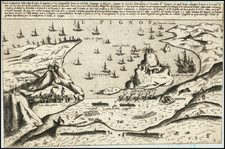
Celebrating the Conquest of Tunis
Rare map of the Conquest of Tunis, published in Venice in 1566. The map is oriented with the south at the top, showing the an array of military encamps and naval battles. The map is dawn from the rare map of Agostino de Musi, published to illustrate the 1535 conquest of Tunis by the Christian fleet under the command of Charles V.
Oriented to the south. Shows the harbor of Tunis and the fort of La Goletta.
The full title is:
Benigni Lettori, per rappresentarui piu particulari della Città di Tunesi, holla tenuta alquanto piu larga di quello che importa la pianta di essa Città secondo la mesura, ò scala delli miglia, laquale solamente ui seruirà à sapere le distantie da un luogho all’altro: Piu altra i monti che sono alla sinestra dello stagno per la loro asprezza no[n] si possono cultiuare, le Colline alla destra sono tutti fruttifere, lo stagno non è nauigabile se no[n] per lo canale. La Torre appresso la Goletta è per la difesa de’ pozzi da quali si ha l’acqua per uso della Città: Le Mura che abbracciano i borghi sono di altezza di tre braccia, et debolossime, et solo fatte per reparar all’improuiso assalto de gli Arabi; Bardo, Mescia, et Restabia sono serragli del Re: jl Borgo Rabat è habitato da Soldati Christiani: jl Borgo Nifet da gli Arabi: jl Mercator del bestiame si fa nella piazza appresso la Meschita: La Piazza de’ Christiani è alli Magazeni: il porto appresso le ruine di Cartagine è quasi ripieno, et no si usa piu: Venetijs ex æneis formis Bolognini Zalterij Anno . M . D . LXVI”.
Translation:
Dear Reader, to represent you more particular of the City of Tunesi, all shown somewhat larger than what the plan of that City matters according to the measure. scale of miles, which only will serve you to know the distances from one place to another: More other the mountains that are to the left of the pond due to their harshness cannot be cultivated, the Hills to the right are all fruit-bearing, the pond is not navigable otherwise nor for the canal, La Torre next to the Schooner for the defense of wells gives which water is available for the use of the city: The walls that embrace the villages are three fathoms high, and very weak, and only made to repair the sudden onslaught of the Arabs; Bardo, Mescia, and Restabia are the King's menageries: jl Borgo Rabat is inhabited by Christiani Soldiers: jl Borgo Nifet from the Arabs: jl Cattle market takes place in the square near the Meschita: The Piazza de Christiani is at the Magazeni: jl port near the ruins of Carthage is almost filled, and is no longer used: Vènetijs ex aeneis formis Bolognini Zalterij Anno .M.D.LXVI
Conquest of Tunis in 1535
The Conquest of Tunis in 1535 was a successful capture of Tunis, then under the control of the Ottoman Empire, by the Habsburg Empire of Charles V and its allies.
In 1533, Suleiman the Magnificent ordered Hayreddin Barbarossa, whom he had summoned from Algiers, to build a large war fleet in the arsenal of Constantinople. Barbarossa conducted aggressive raids along the coast of Italy, until he conquered Tunis on August 16, 1534, ousting Muley Hasan, who was loyal to the Spanish. Barbarossa thus established a strong naval base in Tunis, which could be used for raids in the region, and on nearby Malta.
Charles V assembled a massive force to take back Tunis, including the carrack Santa Anna and the Portuguese galleon São João Baptista, also known as Botafogo (the most powerful ship in the world at the time, with 366 bronze cannons) to drive the Ottomans from the region.
On June 1, 1535, aided by a Genoese fleet, Charles V destroyed Barbarossa's fleet and, after a costly yet successful siege at La Goletta, captured Tunis. In the action, the Portuguese galleon Botafogo distinguished itself by breaking the chains protecting the harbor's entrance with its spur ram, thereafter opening fire on La Goletta.
Barbarossa managed to escape to the harbour of Bône, where a fleet was waiting for him. From there, he sailed to accomplish the Sack of Mahon, where he took 6,000 slaves and brought them to Algiers.
The Ottomans recaptured the city in 1574. However the Ottoman governors of Tunis were semi-autonomous Beys who acted as privateers against Christian shipping. Consequently, raiding in the Mediterranean continued until the suppression of the Barbary Pirates in the early 19th Century and the subsequent French invasion leading to the creation of French Algeria in 1830, and the establishment of a protectorate over Tunisia in 1881.
States of the Map and Rarity
There are 4 states of the map:
- State 1: No Zaltieri imprint or date
- State 2: Zaltieri imprint and date of MDLXVI
- State 3: Orlandi Imprint added and date of 1602 added.
- State 4: Orlandi name mostly removed
The map is very rare on the market.
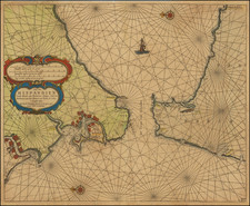
![(North Africa) La Barbarie et l'Egypte [on sheet with] Sein de Carthage [on sheet with] Aegypte](https://storage.googleapis.com/raremaps/img/small/85149.jpg)
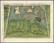
![[Africa] Tabula II Aphricae. (title on verso) (shows Malta and part of Sicily and Sardinia)](https://storage.googleapis.com/raremaps/img/small/103261.jpg)