|
||

|

|
|

|
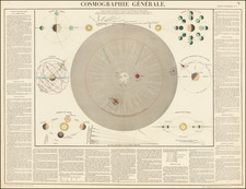
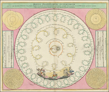
Fine old color example of this scarce world map from Doppelmayr's Celestial Atlas.
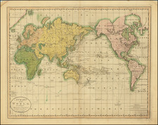
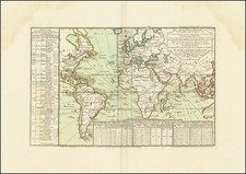
World map in a stereographic projection based on the astronomically determined co-ordinates of 142 towns and cities deduced from observations of luni-solar eclipses and eclipses of the Jovian satellites. The longitudes are measured with respect to the island Ferro (El Hierro in the Canary Islands), assumed to lie exactly 22° 30' West of the Paris Observatory. Engraved between 1720 and 1722.
The map includes California as an Island, an incomplete eastern & southern coast of Australia, incomplete New Zealand and Northwest Passage.
The map is embellished with a large decorative allegorical cartouche. The double hemispheres are surrounded by celestial phenomena, including a solar and lunar eclipse and 3 groups of Cherubs making astronomical observations using the latest astronomical tools.
A fascinating blend of science and decorative cartography, splendidly engraved in the style of the Homann family.
![[ Genesis / Creation ] De Schepping der Wereldt Volgens de Beschryving van Mozes. 1 Plaat [in set with] De Schepping der Wereldt Volgens de Beschryving van Mozes. 2. Plaat](https://storage.googleapis.com/raremaps/img/small/101543.jpg)