


|
||

|

|
|

|
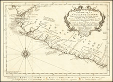
Fine old color example of this decorative sea chart of the Northwest African Coastline, from the Straits of Gibraltar to the Gambia River, published by Frederick De Wit.
The chart is oriented with east at the top, with the Canary Islands (Fuerteventura, Lanzarote, Tenerife, Gran Canaria, La Gomera and La Palma), Madeira, Cape Verde and the Azores (Faial, Pico, Graciosa, Terceira, Santa Maria, Formigas, São Miguel), bottom left Flores.
The chart is embellished with a decorative cartouche, multiple sailing ships, loxodromes and a compass rose.
During the late 17th century, Dutch sea charts were instrumental in navigating the seas and developing trade routes along the coast of Northwestern Africa. These charts provided valuable information about the the region, allowing European explorers and traders to safely navigate the waters and establish colonies in the region.
During this period, several European powers, including the Dutch, the English, and the French, established colonies along the northwest coast of Africa. These colonies were primarily established to facilitate trade and commerce between Europe, Africa and the Americas, with the Europeans seeking to exploit the natural resources of the region, including gold, ivory, and slaves.
The Dutch established a significant presence in the region, with several trading posts along the coast of what is now modern-day Morocco. These posts were established to facilitate trade with the local populations and to protect Dutch ships from the frequent attacks by Barbary pirates. The Dutch also established a colony on the island of Gorée, off the coast of modern-day Senegal, which served as a significant center for the slave trade.
The English established a trading post at the port of Tangier, in modern-day Morocco, which they later abandoned. They also established several trading posts along the coast of modern-day Gambia, which served as a significant center for the slave trade.
The French established several colonies along the coast of modern-day Mauritania, Senegal, and Gambia, which were primarily focused on the slave trade. These colonies were later used as bases for the French exploration and colonization of other parts of Africa.
The commerce and trade along the northwest coast of Africa in the late 17th century were primarily focused on the export of natural resources, including gold, ivory, and slaves. The Europeans would trade these resources for goods such as textiles, guns, and spices. The slave trade, in particular, was a significant source of income for European traders, with an estimated 10 million Africans being transported to the Americas between the 16th and 19th centuries.
De Wit (1629 ca.-1706) was a mapmaker and mapseller who was born in Gouda but who worked and died in Amsterdam. He moved to the city in 1648, where he opened a printing operation under the name of The Three Crabs; later, he changed the name of his shop to The White Chart. From the 1660s onward, he published atlases with a variety of maps; he is best known for these atlases and his Dutch town maps. After Frederik’s death in 1706, his wife Maria ran the shop for four years before selling it. Their son, Franciscus, was a stockfish merchant and had no interest in the map shop. At the auction to liquidate the de Wit stock, most of the plates went to Pieter Mortier, whose firm eventually became Covens & Mortier, one of the biggest cartography houses of the eighteenth century.
![[Azores] Carta Reducida y General de Las Islas de los Azores . . . 1781 [east sheet]](https://storage.googleapis.com/raremaps/img/small/93245.jpg)
![[Southwestern Coast of Africa] Pas-Caart van Guinea en de Custen daer aen gelegen Van Cabo verde tot Cabo de Bona Esperanca](https://storage.googleapis.com/raremaps/img/small/46931.jpg)
![Carte generale de l'Empire romain [des Sarrasins]](https://storage.googleapis.com/raremaps/img/small/82000.jpg)