![Pascaart vertoonende de zeecusten van Chili, Peru, Hispania Nova, Nova Granada, en California…. [Early New Zealand Inset] By Hendrick Doncker](https://storage.googleapis.com/raremaps/img/small/65168.jpg)


|
||

|

|
|

|
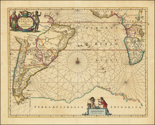
The rare first state of Doncker's Sea Chart, which extends from the Island of California to Chili, with noteworthy insets of New Zealand, the Ladrones and Japan & Ieso. The projection of California based upon Sanson's maps of 1656, with even greater sea between California and the mainland. The Canal de Santa Barbara, Monte Rey, P. Concepsion, S. Diego, Mendocino, S. Quentin, C. Blanco and many other early placenames appear. Excellent detail throughout the Pacific Coast. This is one of the earliest regional maps to focus on the Pacific Coast. In addition to the remarkable treatment of California and the Pacific Coast, the inset of New Zealand is a wonderful early detailed treatment of Abel Tasman's discoveries in New Zealand, including 5 placenames. This is the rare first state of the map, predating the inclusion of the Gulf Coast of Central America, which has appeared in only 1 dealer catalogue since 1990 (Robert Ross, 1995). Minor restorations along the margins and centerfold, as usual, the map having been typically cut close or into the neatlines in the earliest edition of the Doncker's Zee Atlas. In all a very attractive example. McLaughlin 21; Wagner 382; Leighly 36; Lowery 150; Howse & Sanderson 61; Putman 134-35; Goss 35.
Hendrik Doncker was a prominent bookseller in Amsterdam best known for his sea charts and nautical atlases. He issued his own original charts, which he updated frequently, and also worked with colleagues like Pieter Goos, for example to produce the pilot guide, De Zeespeigel. He died in 1699, after fifty years in business. His plates then passed to Johannes van Keulen.
![[Central Riverside County] Riverside Quadrangle](https://storage.googleapis.com/raremaps/img/small/83568.jpg)
![[ New Zealand ] Partie De La Nle. Zelande. Oceanique No. 59 [with] Partie De La Nle. Zelande. Oceanique No. 60](https://storage.googleapis.com/raremaps/img/small/74654.jpg)