|
||

|

|
|

|
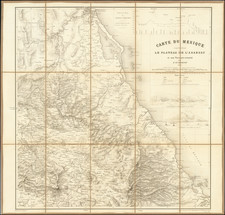
Johannes Metellus Map of Mexico, One of the Earliest Printed Maps of New Spain
A nice example of Metellus's map of western New Spain, showing the recently-created Spanish settlements, many rivers, and large lakes, including Lake Chapala and a mythical sea with islands in the northwest.
The map is based upon Abraham Ortelius's map of the same title, published in Antwerp in 1579.
Scholars still disagree over the sources for the map, although one suggests that Ortelius used Jean Duran's map of Mexico from 1575. What is evident is the level of detail Ortelius felt confident in including about Spain's new colony and its indigenous people. In the northeast, near a mountain range, he writes, "This is a deserted region, where people live in the woods, who highly favor rotting meat, somewhat cooked in the sun. They often fight among each other while collecting harvests and fruits." Further west, he had heard of people who practice anthropophagy, "They who live in these mountains are cannibals."
Rarity
Metellus maps are rare on the market.
Translations from http://www.orteliusmaps.com/book/ort13.html.
Magali M. Carrera, Traveling from New Spain to Mexico: Mapping Practices of Nineteenth-Century Mexico (Durham: Duke University Press, 2011).
Johannes Matalius Metellus, also known as Jean Matal or Johannes Metellus Sequanas, was born in Poligny, Burgundy, France in ca. 1517. A humanist scholar, he was a polymath devoted to cartography, geography, law, paleography, and antiquarianism. Late in life he published a series of atlases; all his maps and atlases are rare and highly sought-after.
Matal was educated at Dole, Freiburg, and several Italian institutions. At Bologna, he met Antonio Agustín, a Spanish legal scholar, who recruited Matal to be his secretary. Together, the men researched ecclesiastical law, with an especial emphasis on Roman legal manuscripts, with trips to Venice, Florence, and elsewhere in Italy to study codices. In 1555, the two traveled to England to meet with Queen Mary on a mission for the Church.
After leaving his employment with Agustín, Matal traveled in the Low Countries and eventually settled in Cologne. There, he mixed with other savants, including especially Georg Cassander and Pedro Ximénez. It was in Cologne that Matal began his serious interest in mapmaking. He contributed to Braun and Hogenberg’s Civitae Orbis Terrarum; Georg Braun described him in glowing terms, “vir omni scientiarum genere praestans"—"a man outstanding in every form of knowledge."
Late in life, Matal began preparing a set of maps of the entire world. In 1594, he published an atlas of France, Austria, and Switzerland (39 maps), in 1595 an atlas of Spain (10 maps), and, posthumously, an atlas of Italy (37 maps), and one of Germany and the Netherlands (55 maps). Many of these maps were combined and augmented into atlases of Europe, Asia, Africa, the Americas, and the world’s islands. In 1602, a compendium work showcased all of these previous works called Speculum Orbis Terrae; this atlas was well received by contemporaries like Walter Raleigh and is very rare today. Many of these maps and atlases were released after his death in 1598, they were finished by his friend and fellow mapmaker Conrad Loew (Matthias Quad).
![[Manuscript Map of Land Dispute in Veracruz]](https://storage.googleapis.com/raremaps/img/small/55847.jpg)