|
||

|

|
|

|
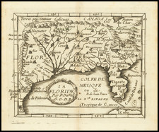
Scarce and highly desirable map of the Chesapeake region, engraved by Peter Van der Keere (Kaerius) and issued in the 1630 Cloppenburg edition of Mercator's Atlas sive Cosmographicae.
The map is the fourth derivative of John Smith's landmark 1612 map of Virginia. The map is substantially enlarged from earlier editions of this atlas. Includes dozens of early place names, Indians tribes, etc.
A scarce derivative of perhaps the single most important map of the region to be published in the 17th Century.
Johannes Cloppenburg (sometimes Cloppenburgh; also H. Jan Evertsz and Johannes Everhardus) was a Dutch cartographer. Based in Amsterdam, he was active between roughly 1610 and 1644. He worked closely with the Hondius/Jansson firm and is credited with the 1630 edition of the Atlas Minor.
![[ Port Royal, South Carolina ]](https://storage.googleapis.com/raremaps/img/small/81298.jpg)
![[Rare First State] Novissima Tabula Regionis Ludovicianae Gallice dictae la Louisiane . . .](https://storage.googleapis.com/raremaps/img/small/72622.jpg)