|
||

|

|
|

|
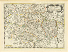
Fine Original Color -- Dauphine on the eve of the Nine Years War
Fine old color example of Pierre Mortier's map of the Dauphine region of southeastern France.
Dauphine is a former province in southeastern France, whose area roughly corresponded to that of the present departments of Isère, Drôme, and Hautes-Alpes. The Dauphiné was originally the Dauphiné of Viennois.
The region is shown just before the Nine Years War. In 1692, during the Nine Years' War, the Duke of Savoy invaded the Dauphiné. Gap and Embrun were badly damaged. But the Savoy armies were defeated by the French Marshal Nicolas Catinat and Philis de La Charce leading a peasant army.
In 1713, the Treaty of Utrecht changed the borders of Dauphiné. The province gained the town of Barcelonette but lost the major part of the Briançonnais.
Pierre, or Pieter, Mortier (1661-1711) was a Dutch engraver, son of a French refugee. He was born in Leiden. In 1690 he was granted a privilege to publish French maps in Dutch lands. In 1693 he released the first and accompanying volume of the Neptune Francois. The third followed in 1700. His son, Cornelis (1699-1783), would partner with Johannes Covens I, creating one of the most important map publishing companies of the eighteenth century.

![[Perpignan]](https://storage.googleapis.com/raremaps/img/small/75063.jpg)
![[Duke of York's Copy] Le Toulois ou sont Les Chatellenies et Les Prevotes du Temporel de l'Eveche de Toul et de son Chapitre; Partie du Balliage de l'Eveche de Verdun. Le Duche de Barrois ou Balliage de Bar le Duc . . .](https://storage.googleapis.com/raremaps/img/small/71292.jpg)