|
||

|

|
|

|
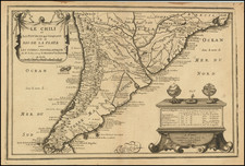
Important early map of Chili, locating many towns west of the Andes and showing Guiramatas in the east.
The map is based upon the 1597 map of Cornelis Wytfliet. The first edition of Wyfliet's work is 'the first atlas of America' (Burden), and was first published in Latin in 1597. The work was marketed as a supplement to Ptolemy's Geographia, with text based on the writings of Ramusio, Hakluyt, de Bry, Acosta and others.
While the Metellus maps were produced after those by Wytfliet, they are far rarer; Wytfliet's maps went into numerous 17th-century editions, while this is a true 16th-century edition of the map.
Johannes Matalius Metellus, also known as Jean Matal or Johannes Metellus Sequanas, was born in Poligny, Burgundy, France in ca. 1517. A humanist scholar, he was a polymath devoted to cartography, geography, law, paleography, and antiquarianism. Late in life he published a series of atlases; all his maps and atlases are rare and highly sought-after.
Matal was educated at Dole, Freiburg, and several Italian institutions. At Bologna, he met Antonio Agustín, a Spanish legal scholar, who recruited Matal to be his secretary. Together, the men researched ecclesiastical law, with an especial emphasis on Roman legal manuscripts, with trips to Venice, Florence, and elsewhere in Italy to study codices. In 1555, the two traveled to England to meet with Queen Mary on a mission for the Church.
After leaving his employment with Agustín, Matal traveled in the Low Countries and eventually settled in Cologne. There, he mixed with other savants, including especially Georg Cassander and Pedro Ximénez. It was in Cologne that Matal began his serious interest in mapmaking. He contributed to Braun and Hogenberg’s Civitae Orbis Terrarum; Georg Braun described him in glowing terms, “vir omni scientiarum genere praestans"—"a man outstanding in every form of knowledge."
Late in life, Matal began preparing a set of maps of the entire world. In 1594, he published an atlas of France, Austria, and Switzerland (39 maps), in 1595 an atlas of Spain (10 maps), and, posthumously, an atlas of Italy (37 maps), and one of Germany and the Netherlands (55 maps). Many of these maps were combined and augmented into atlases of Europe, Asia, Africa, the Americas, and the world’s islands. In 1602, a compendium work showcased all of these previous works called Speculum Orbis Terrae; this atlas was well received by contemporaries like Walter Raleigh and is very rare today. Many of these maps and atlases were released after his death in 1598, they were finished by his friend and fellow mapmaker Conrad Loew (Matthias Quad).

![[Tierra Del Fuego / Straits of Magellan, etc.] Carte Des Cotes de L'Amerique Meridionale depuis le Parallele 36° 30' late. Sud jusqu'au Cap de Horn Levée en 1789, 1790, &c. par des officiers de la Marine en 1800](https://storage.googleapis.com/raremaps/img/small/57719.jpg)
![[ Patagonia / Chile / Argentina ] A New Map of the Southern Parts of America taken from Manuscript Maps made in the Country and a Survey of the Eastern Coast made by Order of the King of Spain.](https://storage.googleapis.com/raremaps/img/small/100772.jpg)
![[ Alaska / Cabo San Lucas / San Blas / Chile ] Views of Headlands and Islands on the Coasts of North West and South America](https://storage.googleapis.com/raremaps/img/small/88077.jpg)