|
||

|

|
|

|
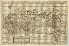
Rare, Richly Decorated French World Map
Fine, uncommon double-hemisphere world map, first published in Paris by Melchior Tavernier in 1630.
The map is based on Jodocus Hondius the Younger’s world map of 1617 or possibly Honervogt's map of 1625, with one noteworthy change. The ecliptic curves on Tavernier's map are reversed so that the line is north of the equator in the western hemisphere and south of the equator in the eastern hemisphere.
In the western hemisphere, a large North America opens to the north, reflecting the relative lack of European experience with that region. Navigators, merchants, and dreamers still hoped to find a Northwest Passage in that area, however, and several expeditions had been sent to find such a waterway. Notes near Hudson’s Bay chronicle some of these explorers, including John Davis and Henry Hudson himself. The base map, by Hondius, was one of the earliest to show Hudson's Bay and the full course of the St. Lawrence River, albeit in a curious configuration.
In what is today California is the toponym Quivira Regn. Quivira refers to the Seven Cities of Gold sought by the Spanish explorer Francisco Vasquez de Coronado in 1541. In 1539, Coronado wandered over what today is Arizona and New Mexico, eventually heading to what is now Kansas to find the supposedly rich city of Quivira. Although he never found the cities or the gold, the name stuck on maps of southwest North America, wandering from east to west.
In northern South America is the mythical Lake Parime. Farther south, at the tip of South America, are two incomplete coastlines. One is Tierra del Fuego, shown in the pointed configuration characteristic of Dutch maps of the seventeenth century. Slightly to the east is Staten landt, connected to a long coastline of a southern continent. It is separated from Tierra del Fuego by the Fr. Le Maire.
Hondius’ 1617 map was one of the first world maps to show the Straits of Le Maire, as well as the islands in the Pacific discovered by Schouten and Le Maire and their explorations in New Guinea. They circumnavigated the world from 1615 to 1617. Their goal was to enter the Pacific not through the Straits of Magellan, which were subject to a trade monopoly by the Dutch East India Company, but by an alternative route. They found that route east of the one found by Magellan, crossed the Pacific—leaving Dutch toponyms as they went—and sailed near much of New Guinea before returning home via the Indian Ocean.
The coastline of the southern continent grows in the eastern hemisphere, encompassing what is today Australia. Farther north, the Strait of Anian narrowly separates North America from Asia.
A cartouche fills much of the southern portions of the eastern hemisphere, decorated with a globe-clutching dog. Another cartouche, in the south of the western hemisphere, is flanked by two Indigenous American men. It includes a note about the changeable nature of geography in the seventeenth century. Farther north, two Indigenous American women are at either side of another cartouche, this one explaining how America was encountered (Columbus) and named (Vespucci). In the seas of the world are numerous ships in full sail, men riding a sea horse, and sea monsters.
The decorative features continue outside the space of the hemispheres. There are two smaller celestial hemispheres between the terrestrial circles; they show the stars of the northern and southern skies. Each corner has a vignette of one of the four seasons, while the space next to the celestial spheres has imagery related to the four elements.
States and rarity
The present example is the first state of the map (1630). This state featured in Tavernier’s Théàtre of 1632 and 1634. A second state was published in 1636; it was included in the Théàtre editions of 1636 and 1637. A third state appeared in 1638.
The map, especially in its first state, is extremely rare. Shirley mentions one example only of the first state, in the Bibliothèque Ste. Geneviève in Paris. Worldcat lists an example at the Université Catholique de l'Ouest.
We note only a single example at auction or in a dealer catalog in the past forty years (Reiss & Sohn, Auction 133, October 2009, Lot 3179).
We have previously offered a second state (1636) example of the map.
This strait, believed to separate northwestern America from northeastern Asia, was related to the centuries-long quest to find a Northwest Passage connecting the Atlantic Ocean to the Pacific. The rumor of this strait and a Northwest Passage in general inspired many voyages of discovery, including those of John Cabot, Sir Francis Drake, Gaspar Corte-Real, Jacques Cartier, and Sir Humphrey Gilbert.
The term Anian itself comes from Marco Polo’s thirteenth-century accounts of his travels. Polo used the term to refer to the Gulf of Tonkin, but cartographers thought it could refer to this supposed strait between Asia and North America. The Strait of Anian, so named, first appeared in a 1562 map by Giacomo Gastaldi, and was later adopted by Bolognini Zaltieri and Gerard Mercator.
The search for a Northwest Passage to the eighteenth century
Today, the most famous expeditions in search of the Northwest Passage are those that took place in the mid-nineteenth century, including the ill-fated Franklin voyage. However, finding a passage to Asia via a northern route was a centuries-old endeavor. Indeed, Ptolemy, in the second century CE, suggested that there was a sea route between Europe and East Asia. The expansion of the Ottoman Empire in the fifteenth century led Columbus and De Gama to explore for alternative access to Asian markets to the west and south. The information they brought back led Europeans to look to the northwest and northeast for a shorter, yet treacherous and icy, way to China.
The first recorded search for the Northwest Passage was the voyage of John Cabot in the late fifteenth century, following in the wake of Norse voyages to North America that occurred in the eleventh century. With the support of Bristol merchants, Cabot landed in Newfoundland in 1497. The following year, in a voyage supported by Henry VII, he left with five ships and 200 men; the squadron never returned. In the early sixteenth century, John’s son, Sebastian, led several voyages to what is today Canada.
Early English and French voyages to North America were constantly on the look-out for passages that might lead to the Pacific. For example, Jacques Cartier led an expedition at the behest of Francis I of France. Cartier ranged over the coasts of Newfoundland and the Gulf of St. Lawrence; he was the first European to contact Prince Edward Island, which, alas, was not the Northwest Passage. A second voyage took Cartier to the location of Quebec, which he claimed for France.
The Spanish too sought the Northwest Passage. They originated the toponym of the Strait of Anian, a displacement of a place name from Marco Polo’s writings, which soon caught on with mapmakers across Europe. Conquistador Hernán Cortés funded the voyage of Francisco de Ulloa from Acapulco north in search of the western entrance to the Passage. He got to the Gulf of California before turning back.
The English did not mount many expeditions during the reign of Henry VIII, who was more focused on the power balance in Europe, but under Elizabeth I many voyages set out to the northwest. Martin Frobisher, a privateer, led three attempts on the Passage in 1576, 1577, and 1578. He thought that he had discovered gold in Frobisher Bay, on Baffin Island, but it turned out to be iron pyrite.
John Davis also led three expeditions north, in 1585, 1586, and 1587. He sailed along Greenland, Baffin Island, and Labrador, as well as charted the Davis Strait. He also found the entrance to Hudson Strait, which would be named for Henry Hudson thirty years later.
John Smith searched for the passage while sailing up Chesapeake Bay in 1608. He did not find it, but he wrote to his friend Hudson that he thought it still might lie just to the north. In the employ of the Dutch East India Company (VOC), Hudson set out in 1609. He first ventured up the Hudson River; while this was again no Northwest Passage, it did help the Dutch to colonize New York, or New Amsterdam as they called the settlement. In 1610, Hudson tried again, this time entering the eponymous Hudson Bay. His ship was trapped in the ice, his crew mutinied, and Hudson, his son, and seven others were set adrift in a small boat, never to be seen again.
One of the mutineers who escaped trial was Robert Bylot, who accompanied Thomas Button on his Arctic voyage in 1612-13. Bylot also accompanied William Baffin to the Arctic in 1615 and 1616; their reports of Baffin Bay were considered fantastic until revisited by John Ross two hundred years later.
Two further explorers, Luke Foxe and Thomas James, went on separate voyages in 1631. Foxe investigated the western shore of Hudson Bay, while James visited the south. These were the last English attempts on the Passage for a century, but the names of Frobisher, Davis, Hudson, Button, Baffin, Foxe, and James are still sprinkled liberally in the high latitudes of the Arctic. The Hudson’s Bay Company (HBC) was founded in 1670, but they focused on trade, rather than exploration, until new attempts were made in the 1720s.
One of the defining features of this and many maps of South America is a massive lake in the north, near Guiana. This is Lake Parime, a feature long-connected to the El Dorado myth. Rumors of a golden city in the New World were first tied to an initiation ceremony for a new chief of the Chibcha (Muisca) people. Bejewelled and covered in gold dust, the chief was supposedly ritually cleansed in sacred Lake Guatavita while more precious stones and metals were thrown into the water. El Dorado, as described by sixteenth and seventeenth-century chroniclers like Oviedo, Castellanos, and Freyle, was a reference to this “golden man.”
Quickly, the golden man was spun into stories of a golden city, which was supposed to perch on the shores of a vast lake. The precise location of both lake and city varied, however. Some searched in the Andes, others the interior. Gonzalo Pizarro set out east of the Incan Empire to find the city and instead lost nearly all of his 4,000 mean. One of his officers, Orellana, was ordered to continue the search and he eventually reached the Atlantic via the Amazon, the first European to do so.
Still others thought the lake and rich city must be near the Orinoco River. Expeditions in this area reached the ears of Sir Walter Raleigh, who led an expedition to Guiana in 1595. While his search failed, Raleigh sent another man, Lawrence Keymis, the next year. Keymis brought back word that a rich city, Manoa, did exist and that it was located on the shores of a Lake Parime. Raleigh published the information in his voyage account, thus popularizing Lake Parime as a geographic feature.
The lake appeared on maps from 1596 until the eighteenth century. The first was Jodocus Hondius’ Nieuwe Caerte van het Wonderbaer ende Goudrycke Landt Guiana. The lake is usually shown as a rectangular body of water on or near the Orinoco River as it approaches the equator. This quadrilateral of a lake is based on the interpretation of the body of water by Hessel Gerritsz in his 1625 Guiana sive Provinciae. While fewer and fewer maps featured the lake as the eighteenth-century wore on, the story was not disproven until the travels of Alexander von Humboldt in South America (1799-1804).
Melchior Tavernier was a member of a large family involved in the publishing trade in Paris in the early years of the seventeenth century. Early in his career, he apparently collaborated with Henricus Hondius, as at least one of his early maps references Tavernier as the seller of a map engraved in Amsterdam, by Hondius. He is probably best known for his publication of a map of the Post Roads of France, which was copied many times until the end of the century. He also issued an atlas under the same title as J. le Clerc's Theatre Geographique, using many of Le Clerc's maps, but incorporating others from different sources. He published composite atlases and also published works for other cartographers, including N. Sanson, N. Tassin, and P. Bertius. He is not to be confused with his nephew of the same name (1594-1665), who also engraved maps for Nicolas Sanson.
![[ Hesiod's World Map ] Hesiodische Welt-Tafel von I.H. Voss](https://storage.googleapis.com/raremaps/img/small/102650.jpg)