This item has been sold, but you can enter your email address to be notified if another example becomes available.


|
||

|

|
|

|
Stock# 74607
Description
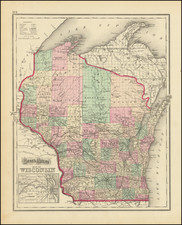
Nice early example of Colton's map of Wisconsin.
Wisconsin became a territory in 1836 and a state in 1848. The map shows several counties whose names would later change, including Bad Ax (Vernon) and LaPointe (Bayfield). A number of the northern counties are still not formed.
Decorative borders and an inset of Milwaukee.

![[ Map of the Mississippi River ]](https://storage.googleapis.com/raremaps/img/small/99811.jpg)