


|
||

|

|
|

|
A Landmark World Map of the Mid-17th Century
Fine example of Giovanni Battista Nicolosi's 2 sheet map of the world, published in Rome in 1660.
This world map by Sicilian geographer Giovanni Battista Nicolosi (biography below) is responsible for two cartographic landmarks. Constructed on a polyconic map projection, Nicolosi's world map is the first use of this projection on a printed map, a projection which would become one of the standard projections in the 18th, 19th and early 20th centuries. In addition, Nicolosi was the first to accurately depict the course of the Rio Grande River flowing into the Gulf of Mexico, reversing a tradition of the river flowing into the Gulf of California (Sea of Cortez), one of the pervasive myths of early American Cartography.
Also of note, Nicolosi's map is the second printed map on a hemispheric projection to show the Pacific Ocean at the center of the world, preceded only b y the 1598 Francis Drake map.
Mapping The World on the Nicolosi Globular Projection
This map is the product of Nicolosi’s novel approach to global mapping. Essentially, he combined the traditions and perspectives of 16th century Roman and Venetian mapmakers with the latest approaches of contemporary greats, above all the modern scientific approach best reflected by French mapmaker Nicolas Sanson. This amalgamation of traditions and styles meant that Nicolosi could come up with an entirely new way of portraying the world, especially when it came to larger landmasses where the curvature of the Earth affected the way in which such terrain could be portrayed.
Nicolosi was the first to employ the so-called polyconic or pseudo-perspective projection in which the established meridians were perfected with the introduction of complimenting circular parallels. Over the next decades, and especially during the early 18th century, this projection technique - also known as the globular projection - became increasingly popular and was applied by seminal cartographers such as Guillaume de l’Isle and Aaron Arrowsmith. In the decades after Nicolosi’s death, the globular or Nicolosi projection replaced the stereographic projection popularized by Mercator, which had increasingly fallen into disuse by then. During the 19th century, the Nicolosi perspective became the standard cartographic projection technique and it remains in use even today. As such, Nicolosi's work belongs in a sequence that includes foundational figures like Ptolemy and Mercator.
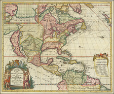
North America
Nicolosi bases his mapping of North America on Sanson's map of 1650, with several notable changes. For example, the Great Lakes are based upon Sanson's map, as is much of the nomenclature along the East Coast. However, in the West, there are several very important differences. The Rio Grande (named Rio Escondido) is shown flowing Southeast into the Gulf of Mexico for the first time ever on a printed map, with an elaborate set of tributaries. The lake which historically fed this river when it was flowing into the Gulf of California has disappeared.
Nicolosi's treatment of the Northwest Passage is also of note. Nicolosi depicts a very distinct open water course from the Atlantic to Button's Bay and on to the Pacific Ocean, one of the most ambitious depictions of the Northwest Passage on a printed map of the period.
On the East Coat of North America various Spanish, French, English and Dutch settlements are noted, including Orange, Cape Cod Pleymouth, N[ew] Amsterdam, Jamestowne, S. Matteo and S. Augustine.
Western Pacific / New Zealand & Australia
Nicolosi’s chart captures the European understanding of the world during an age in which it was undergoing rapid change. This is seen in the strange composition of the Pacific and its western archipelagos. A very tentative outline of New Zealand in the Western Hemisphere, and a similarly vague Australia or New Holland, including Van Diemens Land (Tasmania) in the Eastern Hemisphere, reflects the pioneering Dutch ventures of Abel Tasman and Franchois Visscher to this region in 1642. Nicolosi is in other words incorporating territories discovered no more than a decade earlier, and furthermore by a competing nation that was hostile to the Catholic Church.
Perpetuating Cartographic Myths
Nicolosi's decision to leave the unknown southern continent in place, placing New Zealand beneath the mythical coastline (Terra d Quir, a reference to the 16th Century discoveries of Pedro Fernandes de Queirós), is an example of how Nicolosi was forced to balance the information of known discoveries with those of pervasive, but still unproven depictions of remote places.
Terra Iesso
In the Northwest Pacific, we see clear manifestations of the ample mythology associated with mapmaking. The Jesso and Anian concepts are both cartographic myths that have been extensively explored and explained by scholarship. The etymology of the idiom Jesso is most likely the Japanese Ezo-chi; a term used for the lands north of the island of Honshu. During the Edō period (1600-1886), it came to represent the ‘foreigners’ on the Kuril and Sakhalin islands to the north of Japan.
As European traders came into contact with the Japanese in the 17th century, the term was adopted and incorporated rather uncritically onto European maps, where it was often associated with the island of Hokkaido. The origins of Jesso’s importance can be traced back to Father Francis Xavier (1506-1552), an early Jesuit missionary to Japan and China. Xavier related stories that immense silver mines were to be found on a secluded Japanese island, and these stories were soon strengthened by Spanish traders spreading similar reports. The rumors became so tenacious and widespread that Abraham Ortelius included an island of silver above Japan on his 1589 Maris Pacifici map.
Half a century later, the powerful Dutch East India Company sponsored two voyages of exploration to identify and possibly claim these rich lands for Holland. The first was led by Abel Tasman in 1639, the second by Maarten Gerritzoon Vries in 1643. Vries erroneously perceived Urup as the westernmost fringe of America and mapmakers soon adopted this concept. Over time, variations occurred in which this undefined land came to be referred to as Jesso.
The popular misconception of California as an island can be found on European maps from the sixteenth through the eighteenth centuries. From its first portrayal on a printed map by Diego Gutiérrez, in 1562, California was shown as part of North America by mapmakers, including Gerardus Mercator and Abraham Ortelius. In the 1620s, however, it began to appear as an island in several sources. While most of these show the equivalent of the modern state of California separated from the continent, others, like a manuscript chart by Joao Teixeira Albernaz I (ca. 1632) now in the collection of the National Library of Brasil shows the entire western half of North Americas as an island.
The myth of California as an island was most likely the result of the travel account of Sebastian Vizcaino, who had been sent north up the shore of California in 1602. A Carmelite friar, Fray Antonio de la Ascensión, accompanied him. Ascension described the land as an island and around 1620 sketched maps to that effect. Normally, this information would have been reviewed and locked in the Spanish repository, the Casa de la Contratación. However, the manuscript maps were intercepted in the Atlantic by the Dutch, who took them to Amsterdam where they began to circulate. Ascensión also published descriptions of the insular geography in Juan Torquemada’s Monarquia Indiana (1613) (with the island details curtailed somewhat) and in his own Relación breve of ca. 1620.
The first known maps to show California as an island were on the title pages of Antonio de Herrera’s Descripción de las Indias Occidentales (1622) and Jacob le Maire's Spieghel Der Australische Navigatie (1622). Two early examples of larger maps are those by Abraham Goos (1624) and another by Henry Briggs, which was included in Samuel Purchas’ Hakluytus Posthumus or Purchas his Pilgrimes (1625). In addition to Briggs and Goos, prominent practitioners like Jan Jansson and Nicolas Sanson adopted the new island and the practice became commonplace. John Speed’s map (1626-7), based on Briggs’ work, is well known for being one of the first to depict an insular California.
The island of California became a fixture on mid- and late-seventeenth century maps. The island suggested possible links to the Northwest Passage, with rivers in the North American interior supposedly connecting to the sea between California and the mainland. Furthermore, Francis Drake had landed in northern California on his circumnavigation (1577-80) and an insular California suggested that Spanish power in the area could be questioned.
Not everyone was convinced, however. Father Eusebio Kino, after extensive travels in what is now California, Arizona, and northern Mexico concluded that the island was actually a peninsula and published a map refuting the claim (Paris, 1705). Another skeptic was Guillaume De L’Isle. In 1700, De L’Isle discussed “whether California is an Island or a part of the continent” with J. D. Cassini; the letter was published in 1715. After reviewing all the literature available to him in Paris, De L’Isle concluded that the evidence supporting an insular California was not trustworthy. He also cited more recent explorations by the Jesuits (including Kino) that disproved the island theory. Later, in his map of 1722 (Carte d’Amerique dressee pour l’usage du Roy), De L’Isle would abandon the island theory entirely.
Despite Kino’s and De L’Isle’s work, California as an island remained common on maps until the mid-eighteenth century. De L’Isle’s son-in-law, Philippe Buache, for example, remained an adherent of the island depiction for some time. Another believer was Herman Moll, who reported that California was unequivocally an island, for he had had sailors in his offices that claimed to have circumnavigated it. In the face of such skepticism, the King of Spain, Ferdinand VII, had to issue a decree in 1747 proclaiming California to be a peninsula connected to North America; the geographic chimera, no matter how appealing, was not to be suffered any longer, although a few final maps were printed with the lingering island.
Giovanni Battista Nicolosi (1610-1670), also known as Giovan Battista, was a Sicilian priest, geographer and cartographer, who worked for the Vatican's Congregation for the Evangelization of Peoples (or Propaganda Fide) under Pope Gregory XV. Officially, the Fide office was established to promote missionary work across the globe, but the reality was that it constituted an important office for the maintenance and dilation of the Church’s power in an ever-expanding world.
Arriving in the papal capital around 1640, Nicolosi devoted himself to the study of letters, sciences, geography and languages. In 1642, he published his Theory of the Terrestrial Globe, a small treatise on mathematical geography, and, a few years later, his guide to geographic study, which was a short treatise on cosmography and cartography. Both works reflected a Ptolemaic world view, but his guide to geographic study would soon serve as an introduction to Nicolosi’s real magnum opus, Dell' Ercole e Studio Geografico, which was first published in 1660. His Theory of the Terrestrial Globe, on the other hand, brought Nicolosi to the attention of broader scientific circles and earned him the Chair in Geography at the University of Rome.
In late 1645, Nicolosi travelled to Germany at the invitation of Ferdinand Maximilian of Baden-Baden, where he remained for several years until returning to Rome. Here, Nicolosi was appointed chaplain of the Borghesiana in the Basilica of Santa Maria Maggiore. This honor was conferred on him by Prince Giovanni Battista Borghese, who Nicolosi himself had tutored and in whose palace he had lived since 1651. Years later, Nicolosi would thank the prince for his generosity by dedicating his most seminal work to him.
One of Nicolosi's most significant contributions to the history of science and geography is the so-called map of the world on a globular projection. First published in 1660, Nicolosi's map of the world, produced ny the Vatican, constituted a pioneering innovation in the way in which the physical world was portrayed. This entirely new perspective on geography was groundbreaking and quickly adapted across the cartographic plane. It has consequently come to be known as the ‘Nicolosi projection’. In truth, Nicolosi's globular projection is a polyconic map projection invented by Abū Rayḥān Muḥammad ibn Aḥmad Al-Bīrūnī, the foremost Muslim scholar of the Islamic Golden Age, who invented the first recorded globular projection for use in celestial maps about the year 1000 CE. Nicolosi was almost certainly not awared of the work of Al-Bīrūnī, and Nicolosi's name it typically attributed to the projection.
There exists in the Vatican and other National archives a considerable collection of Nicolosi’s unpublished work. This includes a large chorographic (i.e. descriptive) map of all of Christendom, commissioned by Pope Alexander VII, as well as a full geographic description and map of the Kingdom of Naples, which was sent to Habsburg Emperor Leopold I in 1654.
![[World] Dated Events War Map . . .](https://storage.googleapis.com/raremaps/img/small/88833.jpg)
![[Early Photographic Facsimile of the Catalan-Estense World Map]](https://storage.googleapis.com/raremaps/img/small/66756.jpg)
![[ First State of the First Map of America ] Novae Insulae XVII Nova Tabula](https://storage.googleapis.com/raremaps/img/small/94609.jpg)
![[Globe with California as an Island on Allegorical Jesuit Engraving] Saeculum Nostrum in Illuminatione Vultus Tui Psal 89](https://storage.googleapis.com/raremaps/img/small/93732.jpg)