


|
||

|

|
|

|
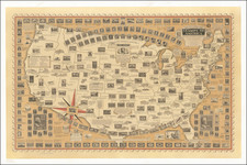
A detailed antique road map of France overlain with the route of the 1952 Tour de France.
The route starts in Strasbourg, then passes through Liege, Lille, Caen, Nantes, Bordeaux, Marseille, and Lyon before arriving in Paris. In addition to these cities, many smaller towns and cols (major climbs) are named along the way. Major roads and rivers are also shown.
This fiftieth anniversary of the Tour saw the introduction of the points system and the green jersey. The race was filled with the usual politics and infighting normal in the early Tour, with vehement rivalries between some of the French riders. Despite this, the Frenchman Bobet won, completing the Tour in just under 130 hours.
This map was printed by the French sports retailer Unis-Sport and shows an advertisement for Lambretta Mopeds.
![(WWII Propaganda Map) Newsmap for the Armed Forces. 257th Week of the War - 139th Week of U.S. Participation. Monday, 14 August 1944. Volume III, No. 17B [and] No. 17F. [on verso:] Let This Do Your Talking!](https://storage.googleapis.com/raremaps/img/small/95408.jpg)
![[Portrait of Louis XV as a child] Ludovicus XV. Franciae et Navarrae Rex Natus 15 Febr. Anno 1710.](https://storage.googleapis.com/raremaps/img/small/95867.jpg)
![(Franco-Prussian War) Fameux Probleme Algebrique & Politique [Famous Algebraic & Political Problem]](https://storage.googleapis.com/raremaps/img/small/86125.jpg)