


|
||

|

|
|

|
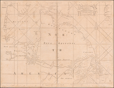
Dutch language manuscript map of Boothia Felix, King William's Island and the surrounding waters, based upon the discoveries of Sir John Ross and his nephew James Clark Ross between 1829 to 1832 and with an additional note suggesting knowledge of George Back's expedition of 1833-34 in search of the Great Slave Lake.
The present map provides a close study of a portion of the area covered by Sir John Ross's expedition of 1829 to 1833, focusing on the period between September 1829, when the expedition moved south to Victory Harbor and Lord Mayor Harbor, as well as several of the sledge trips to the west made by James Ross Clark, which resulted in the discovery of Matty Island and King William Island. As noted at below, it also includes a reference to George Back which would correspond to approximately 1834-35 and a reference to "Kaap Sophia Sidney."
The map appears to reflect the work of at least two hands, one in pencil and one in pen. The pencil notes include a highly detailed set of 5 mileage scales, which strongly suggest that this map was undertaken by a very skilled hand. As such, we believe that this map was likely compiled from one or more contemporary sources, likely in the Netherlands.
The map includes a separate set of pencil notes, which begin in early September 1829 near "Kaap Hanson" north of Pouncet Island and extend south to Victory Bay and Lord Mayor Bay, where the Ross Expedition wintered in 1829-30. At least 3 pencil notes showing anchorages are given for 1829 and 1830 near Victory Harbor and south to Adolphus Island. The pencil notes for a different time period show two separate trips across the Boothia Peninsula and across to either side of Matty Island and on to King William Island, where the course turns northward along the coast of the island, which was apparently explored to its northernmost point, then turning southward until the date "30 Mei", south of Victory Point, when the notes seem to end.
While no tracks of are shown, the map notes a number of point on the west coast of Boothia Peninsula, including the location of "Magnetische Pool van Willem IV", apparently the location where James Clark Ross locating the magnetic North Pole on June 1, 1831.
The majority of the tracks seem to focus on the James Ross's sledge expeditions to the west. During the winter of 1829-30, James Clark Ross made a series of sledge journeys exploring the shoreline on the west side of Boothia, which proved that Boothia was a peninsula as the Inuit had told Sir John Ross and not an island which John Ross had hoped. James crossed what is now called James Ross Strait, and discovered and named Matty Island and Cape Felix. His farthest westward was Victory Point. This part of the coast James named King William Land assuming it was part of the mainland, although it was actually and Island.
Several notes at the far west of the map identify "bach's Baai", "kaap Jan Franklin" and "Franklin's punt". These are references to the discoveries of George Back and John Franklin, which can be seen on printed versions of the map which illustrates Ross's second expedition (see link below).
The reference to Kaap Sophia Sidney is very unusual, and appears to be named Sophia Sidney, Baroness De L'Isle and Dudley (1796-1837), the illegitimate daughter of William IV. This name survived for only a short period of time and appeared on a map in the narrative of Ross's second expedition, . . . Chart of the Discoveries Made in the Arctic Regions in 1829, 30, 31, 32 & 33 . . . https://www.raremaps.com/gallery/detail/64402
Given the elaborate set of 5 scales of miles and significant deviations between the printed map referenced above and the manuscript map, we suspect that this manuscript was created by a very skilled contemporary Dutch hand studying the Ross discoveries.
Sir John Ross
Sir John Ross CB (1777 – 1856) was a Scottish Royal Navy officer and polar explorer. He began his naval career in 1786 at age 9, serving as first class volunteer to HMS Pearl. After rising through the ranks, he undertook his first arctic expedition in 1818.
In 1818, Ross received the command of an Arctic expedition organized by the British Admiralty, the first of a new series of attempts to locate the North West Passage. The expedition left London in April, with Ross commanding Isabella, accompanied by Alexander, under Lieutenant William Edward Parry. Ross sailed counter-clockwise around Baffin Bay, repeating the observations made by William Baffin two hundred years before. In August, he entered Lancaster Sound at the north end of Baffin Island, which would later prove the correct route for the Northwest Passage. He sailed a number of miles west but went no further, for he was misled by a mirage that appeared to show mountains at the end of the strait. He named the apparent mountains "Croker Mountains", then first secretary of the Admiralty, then returned to England despite the protests of several of his officers, including Parry and Edward Sabine, who thought he should have more thoroughly examined the "mountains".
The expedition failed to discover much that was new. Its main effect was to open a route for whale ships to the northern Baffin Bay and provoke Parry to re-explore Lancaster Sound and find a major portion of the North West Passage. Parry, Ross's lieutenant on the previous expedition, returned to the Arctic in 1819, and sailed 600 miles west beyond the "Croker Hills", thereby discovering the Parry Channel, the main axis of the North West Passage.
Partly to redeem his reputation, Ross proposed to use a shallow-draft steamship to break through the ice. The Admiralty was not interested, but he was able to convince the gin-magnate Felix Booth to finance this second Arctic expedition, which began in 1829. His ship was the Victory, a side-wheel steamer with paddles that could be lifted away from the ice and an experimental high-pressure boiler built by John Ericsson. The engine caused trouble and during the first winter, it was dumped on the shore. The ship carried four officers – John Ross, his nephew James Clark Ross, William Thom, surgeon George McDiarmid – and 19 men. The goal was Prince Regent Inlet at the west end of Baffin Island where Parry had lost his ship, the Fury, in 1825.
Ross left in May 1829. Baffin Bay was unusually ice-free and on August 6, he passed the point where he had turned back 10 years before. On August 11, he turned south into Prince Regent Inlet, and on August 11, reached Fury Beach, where Parry had abandoned his ship. The hulk was gone but there were heaps of stores on the beach, some of which he took. Continuing south he became the first European in the Gulf of Boothia, but by the end of September, he was blocked by ice 200 miles south of Fury Beach. He took winter quarters at Felix Harbor at the eastern tip of the Boothia Peninsula. In January 1830, a group of Netsilik Inuit arrived and provided food and information. For one of them, the ship's carpenter made a wooden leg.
In the spring of 1830, Ross's nephew James Clark Ross made several trips west into the interior. On April 9, 1830, he reached the west side of the Boothia Peninsula and in May crossed over ice to the north west shore of King William Island, assuming it was part of the mainland. It was mid-September before the ice broke part of its grip. The crew sawed through the shore ice and warped the ship into open water, but it was soon caught in the ice. October was spent warping and sawing the ship into Sheriff Bay where they spent their second winter only three miles from Felix Harbor. No Inuit arrived until the following April 1831. James Clark Ross crossed the Boothia Peninsula, and, on June 1, 1831, became the first European to reach the North Magnetic Pole. In August, the ship began to move but only managed to travel four miles before it got trapped in Victoria Harbor. By January 1832, it was clear that the ship would never get out. Ross's plan was to drag the ship's boats north to Fury Beach, collect provisions there, find open water and hope to be rescued by a whaler.
The expedition abandoned Victory on May 29, 1832. Ten days later, James Clark Ross returned from Fury Beach and reported that Fury's boats were repairable, which spared them the labor of dragging the boats. They reached Fury Beach on July 1, left in three boats on August 1, and reached Barrow Strait at the end of August. Finding an unbroken field of ice, they waited four weeks for the ice to melt, gave up, returned south, left their boats at Batty Bay, and walked to Fury Beach. On July 8, 1833, they left for Batty Bay and on August 14, saw open water for the first time. They left the next day and reached the head of Prince Regent Inlet. On August 26, they spotted a ship but it passed by. A few hours later, they were seen by another ship, which turned out to be Isabella which Ross had commanded in 1819. Had it not been for his 1819 discovery there would have been no whalers in the area. By October they were back in England.
Ross was presented to the King and given a knighthood. The crew were given double pay for the entire four years by the Admiralty even though they were not in the Royal Navy. This impressive experience, as well as the scientific and ethnological information gathered by Ross's team, brought him the renown that he had long sought. In comparison with other contemporary arctic explorers, this was a feat of heroic proportions and was probably due to the fact that Ross befriended and learned from the Inuit.
Once again, however, Ross encountered controversy with his cartography. In 1830, during the expedition, James Clark Ross had charted three islands in James Ross Strait and named them the Beaufort Islands. John Ross never saw the islands. Later, back in England, John Ross, using his authority as expedition leader, renamed the islands as the Clarence Islands, and even added a number of fictional islands to the group, in an apparent attempt to impress the new king, William IV. In 1833, Ross received gold medals from the English and French geographical societies, and various foreign orders, including Knight of the Royal Order of the Polar Star of Sweden, and in the following year, received a knighthood and was appointed a Companion of the Order of the Bath in Britain. He was as British consul at Stockholm in 1839, and remained at this post until 1846.
In 1850, at the age of 72, Ross undertook a third voyage to the Arctic regions, this time in search of the expedition party of Sir John Franklin, which proved unsuccessful.
![[ Early United States ] Etats Unis De L'Amerique](https://storage.googleapis.com/raremaps/img/small/98746.jpg)
![(Strait of Magellan) Freti Magellanici ac novi Freti vulgo Le Maire exactissima delineatio. [The most exact delineation of the Strait of Magellan and the new Strait, commonly known as Le Maire.]](https://storage.googleapis.com/raremaps/img/small/99612.jpg)