|
||

|

|
|

|
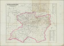
Rare Detailed 19th Century Map of Puebla and Environs
Styled the first edition, this fine lithograph map shows central part of the city of Puebla and the surrounding area. The urban core of the city has the blocks shown tinted red. As would be expected of a city famous for its large number of churches, the map indicates each church with a cross. The Zocalo of Puebla is clearly shown near the center of the sheet.
Relief represented by contour lines, hatching, and spot heights. Lithography by Hipólito Salazar, a prolific Mexican lithographer.
Areas shown on the map, including barrios, villages, haciendas, fincas, forts, and the like:
- Rio San Francisco
- Rio Atoyac
- Rio Xonaca
- Panteon Municipal
- Barrio Santiago
- Barrio Alto
- Barrio Luz
- Fuerte de Loreto
Provenance: Roberto L. Mayer Collection.
Rarity
This is very rare map of Puebla. OCLC locates only a single example of this map, held by a French library.
![A Map of British Honduras... [bound in:] Tratado de Limites Entre Los Estados-Unidos Mexicanos y Honduras Britanica Seguido de los principales documentos que a el se refieren. Edicion Oficial.](https://storage.googleapis.com/raremaps/img/small/70984.jpg)
![(Mexican-Aztec Paintings) [Original watercolor of 4 Aztec Festival Deities]: Veitecuilitl, Miccailhhuitl, Festival of the Dead, Veymiccailhuitl, Ochpaniztl](https://storage.googleapis.com/raremaps/img/small/103004.jpg)