|
||

|

|
|

|
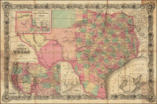
Fascinating early Texas oil and gas exploration map, issued by J.G. Reaves and Associates to promote their lease and royalty holdings. The map shows the geology of Texas, displaying strata of different ages, the locations of proposed wells, and known oil and gas fields. The now-famous drilling areas of the Permian Basin and the oilfields which follow Carboniferous strata can be easily identified to the left and in the center of the map.
The landholdings of J. G. Reaves and Associates are shown in red. These investors possessed several parcels of land in southern and western Texas and used this map to advertise their potential for growth. The company offices were located in the Westbrook Hotel, at the time a center for Texas oilmen and a focal point of the Ranger oil boom in 1917. This famous building would be imploded in the 1970s during the revamping of downtown Fort Worth.
The manuscript annotations on the map are difficult to decipher. They may relate to proposed railroad or oil pipelines or may represent something else entirely.
Curiously, the county layout on the map can be dated to between 1911 and 1913 based on the county organization. Culbertson county, in the Trans-Pecos region, appears, having been founded in 1911. However, Kenedy County (on the Gulf of Mexico) has not yet seceded from Nueces county, which would happen in 1913. However, knowledge of gas and oil reserves in the state was limited to the salt dome provinces of eastern Texas. As this map shows proposed drilling all over the western and central part of the state, it is more likely that this map comes from the second phase of the oil boom in the late 1910s or early 1920s.
The Early Texas Oil Boom
At the time of this map's creation, the so-called "gusher age" was still just beginning to mature. The earliest big strike, at Spindletop, had been less than twenty years before the creation of this map. Speculation in Texas oil production exploded in the 1900s and 1910s. At first, exploration was limited to salt domes in the Houston area, but reserves were rapidly discovered in the Permian Basin and in Jurassic rocks extending into Oklahoma. For the first several decades of the oil boom, speculation dominated and prices swung wildly, driving investors in and out of the market with the ebb and flow of oil prices.
Rarity
No examples of this map appear in the OCLC database.
![(Texas Photograph) [Cabinet Card Birdseye View of El Paso, Texas and Ciudad Juarez]](https://storage.googleapis.com/raremaps/img/small/92983.jpg)


![[Matagorda Bay] Bahia De S. Bernardo](https://storage.googleapis.com/raremaps/img/small/54374.jpg)