|
||

|

|
|

|
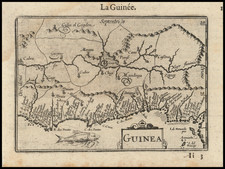
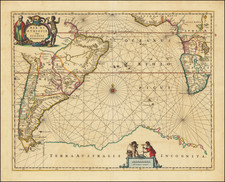
Detailed Map of the Area Around Calabar From a Celebrated Voyage Collection
Fine map of a section of the coast of Nigeria, from the voyage account of Jean Barbot in the Churchill brothers’ renowned voyage collection, published in London in 1732.
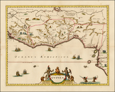
The map titled provides an interesting historical record of European understanding and interest in the African continent, specifically the Calabar River and the adjacent coast of Guinea. The Calabar River, today located in modern Nigeria, was of significant importance during the late 17th and into the 18th century, primarily due to its prominence in trade. The river served as a key route for transportation and commerce, especially during the Atlantic slave trade, which is possibly why it was the focal point of this map.
This map also details the coast of Guinea, including the territories from Cape Formosa to the Dony River, providing an overview of the lands that were gradually coming under European influence during the era of colonial expansion. Trading posts marked on the map reveal the economic interests of European nations such as Portugal, the Netherlands, and England.
The Churchills’ voyage collection
The Churchill brothers, Awnsham (1658-1728) and John (ca. 1663-ca. 1714), were publishers in London who catered to an affluent clientele, and they were from a prominent family themselves. A distant relative was John Churchill, the Duke of Marlborough. Two of their older brothers, Joshua and William, served as Members of Parliament. Awnsham also was elected an MP for Dorchester in the first years of the eighteenth century.
In 1704, they released the first edition of one of their most successful works, A collection of voyages and travels: some now first printed from original manuscripts, others now first published in English. The collection consisted of four volumes of voyages and travel accounts derived from primary sources in English, French, Dutch, Italian, Spanish, and German, a feat not seen since Hakluyt’s work over a century earlier.
The Churchill brothers are perhaps best-known today as the publisher of the works of John Locke. Awnsham supported religious tolerance and moderation for nonconformists, stances that would have appealed to Locke. Locke is supposed to have written the introductory discourse which opens the voyage collection.
This map appeared in the 1732 expanded edition, which extended the collection to six volumes. Barbot’s Description of the Coasts of North and South Guinea featured in the fifth volume. A further edition of eight volumes was issued in 1752.
The collection was widely respected and considered one of the most prestigious examples of the genre in the eighteenth century. The maps and illustrations from the collection are relatively scarce on the market, especially given how important the publication was when it debuted.
Johannes Kip (1653-1722) was a topographical engraver. Born in the Netherlands, he had immigrated to England by 1690. His most famous work are the engravings of country houses in Britannia Illustrata (1707), which he produced with Leonard Knyff. He also contributed to the 1732 expanded edition of the Churchill brothers voyage collection.