|
||

|

|
|

|
Stock# 73448
Description
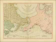
A beautiful map of Northeastern Canada, including Nova Scotia, Labrador, and Newfoundland, published by Tobias Conrad Lotter in Augsburg.
The map's vertical format elongates the geography and distorts the true shape of Newfoundland. The St. Lawrence River runs nearly north-south.
The map is very detailed, especially along the coastlines and rivers. Many place names, both European and Indian.
At bottom right is a scene with several sailing ships. At the top left is a huge decorative title cartouche featuring allegorical figures, Indian chiefs, explorers, mapmakers, a fleet of ships, fishermen, and wildlife.
Reference
Kershaw #344; Moreland and Bannister, p. 90.

![[The Final State] A New Map of North America, with the West India Islands, Divided according to the Preliminary Articles of Peace, Signed at Versailles, 20 Jan. 1783, wherein are Distinguished The United States and the Several Provinces, Governments &c Which Compose the British Dominions . . . 1794](https://storage.googleapis.com/raremaps/img/small/89085.jpg)