|
||

|

|
|

|
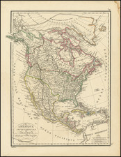
Decorative map of North America, in the style of John Tallis, but with a completely different border and vignettes. Virtue's map is every bit as decorative as Tallis' map, but significantly scarcer.
The map stretches from Panama to the unmapped "Parry Islands" (Queen Elizabeth Islands).
The map includes numerous decorative vignettes from all over the continen. These include views of Polar Bears, Captain Parry's voyages, Icelandic geysers, a whale hunt, an ancient Mexican temple, and the Columbus landing all in the same image!
Despite the late date of publication of this map, the American West is barely recognizable. California stretches westwards to the rocky mountains, as does Oregon. The Missouri Territory forms most of the remaining Midwest east of Minnesota. New Mexico comprises the Texas Panhandle. Alaska is well defined but named Russian America (it would not be transferred until 1867).
Tallis was one of the last great decorative map makers. His maps are prized for the wonderful vignettes of indigenous scenes, people, and more that they often show.
![[The Final State] A New Map of North America, with the West India Islands, Divided according to the Preliminary Articles of Peace, Signed at Versailles, 20 Jan. 1783, wherein are Distinguished The United States and the Several Provinces, Governments &c Which Compose the British Dominions . . . 1794](https://storage.googleapis.com/raremaps/img/small/89085.jpg)