|
||

|

|
|

|
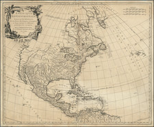
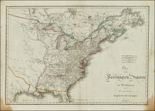
(West Florida Controversy) The United States Divided into 17 Provinces and "Land Claimed by the United States"
Fine late 18th Century map of the United States of America, published in Paris in 1787.
The map extends south to include part of East and West Florida, which were then still controlled by Spain. The western boundary of Georgia extends to the Mississippi River. A thin strip of land extending westward between Georgia and Tennessee is called United States Territory. This region originally belonged to South Carolina but was ceded back to the United States in 1787.
Further south a wide strip of land between Georgia and West Florida is Land claimed by the United States referring to the disputed region between the United States and Spain known as the West Florida Controversy (see below).
The map includes an early appearance of Kentucky (formed in 1792) and Tennessee (1796). The large, mostly blank Maine is here labeled Main, with a massive North Western Terrirory to the north of Kentucky, embracing Ohio, Indiana, Illinois, Wisconsin and Michigan.
West Florida Controversy
Prior to the American Revolutionary War, East and West Florida were British possessions. When Spain entered the American Revolutionary War on the side of France, it was not allied with the Thirteen Colonies. Bernardo de Gálvez, governor of Spanish Louisiana, led a military campaign along the Gulf Coast, capturing Baton Rouge and Natchez from the British in 1779, Mobile in 1780, and Pensacola in 1781.
In the 1783 Treaty of Paris, which ended the war, the British agreed to a boundary between the United States and West Florida at 31° north latitude between the Mississippi and Apalachicola Rivers. However, the separate Anglo-Spanish agreement, which ceded both Florida provinces back to Spain, did not specify a northern boundary for Florida, and the Spanish government assumed that the boundary was the same as in the 1763 agreement by which they had first given their territory in Florida to Britain. This sparked the first West Florida Controversy. Spain claimed the expanded 1764 boundary, while the United States claimed that the boundary was at the 31° parallel. Negotiations in 1785–1786 between John Jay and Don Diego de Gardoqui failed to reach a satisfactory conclusion. The border was finally resolved in 1795 by the Treaty of San Lorenzo, in which Spain recognized the 31° parallel as the boundary.
Spain continued to maintain East and West Florida as separate colonies. When Spain acquired West Florida in 1783, the eastern British boundary was the Apalachicola River, but Spain in 1785 moved it eastward to the Suwannee River. The purpose was to transfer the military post at San Marcos (now St. Mark's) and the district of Apalachee from East Florida to West Florida.
In the secret Treaty of San Ildefonso of 1800, Spain agreed to return Louisiana to France; however, the boundaries were not explicitly specified. After France sold the Louisiana Purchase to the United States in 1803, another boundary dispute erupted. The United States laid claim to the territory from the Perdido River to the Mississippi River, which the Americans believed had been a part of the old province of Louisiana when the French had agreed to cede it to Spain in 1762. The Spanish insisted that they had administered that portion as the province of West Florida and that it was not part of the territory restored to France by Charles IV in 1802, as France had never given West Florida to Spain.