


|
||

|

|
|

|
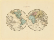
Only the Fourth Known Example of the Exceedingly Rare First State of De Fer’s 1694 World Map (Shirley, 560)
An extremely rare French wall map of the world, this map merits a “RRR” on the Shirley rarity scale.
The map is an ornamental masterpiece, issued by Nicolas de Fer to celebrate the successes of the Paris Observatory and the Académie des sciences in observing the movements of the planets.
The map was originally issued in 1694 without accompanying text (only two known examples of that first edition are cited by Shirley).
The double-hemisphere map is a fine overview of geographical knowledge at the end of the seventeenth century. California is shown as an island, while farther north the Strait of Anian separates an incomplete Anian from the Pacific Northwest. The strait suggestively heads toward Hudson’s Bay or Baffin’s Bay, a significant nod to the much-sought Northwest Passage.
To the south, Tierra del Fuego is the final landmass before an empty Antarctic. De Fer was conservative in his additions here, so there is no hint of a speculative southern continent. As he explains in a note in the interior of Africa, it is better to leave blank space than to fill it with mere possibilities.
In the Pacific is the partial coast of New Zealand as contacted by Abel Tasman on his voyage of 1642-3. Snaking nearby is a ship’s route. This marks the circumnavigation of Willem Schouten and Jacob Le Maire. The Dutch East India Company (VOC) had declared the Straits of Magellan as their own, disallowing non-VOC ships from entering. In an attempt to circumvent these restrictions, the merchant Isaac LeMaire, Jacob’s father, financed a voyage to find an alternative route in 1615. William Schouten and Isaac Le Maire entered the Pacific from the West via a straight that sent their ships around Cape Horn, which they named for their port of departure in the Netherlands. Le Maire’s name was chosen for the Strait, while the island they passed by received the name of Staten Landt. The Schouten and Le Maire expedition also named the Barnevelt Islands after Johan van Oldenbarnevelt, governor of the province of Holland.
This map also shows Brouwer’s Strait. As part of a Dutch West Indies Company expedition to Chile, Brouwer led a fleet from Recife, Brazil in 1643. The Company wanted to join a revolt already started by the Araucano Indians in an attempt to destabilize the Spanish hold on power. Brouwer had his fleet sail on an easterly route, discovering that Le Maire’s Staten Land was insular.
In the eastern hemisphere, the interior of Africa is of particular interest. The Nile River, then as now one of the most important rivers in the world, has a multi-pronged source. The central source stream is in Eastern Africa; indeed, Lake Tana (here Tzana) is the source of the Blue Nile. The other two branches of the Nile, both called the Nubia River, peter out, but one is close to a waterway that leads to the Mountains of the Moon in the south. These mountains are part of a Ptolemaic understanding of the source of the Nile and were common on maps of the time.
Another expedition is marked in Southeast Asia. In 1685-6, Alexander, the Chevalier de Chaumont, led a delegation from France to Siam, which today is known as Thailand. This was the second official French trip to Siam; Chaumont was to deliver two ambassadors and to collect delegates from the first delegation of 1684. The route marked here is Chaumont’s journey to the Cape of Good Hope in 1685 and to the voyage to and from Siam in the Indian Ocean.
Australia was of especial interest to the Dutch at this time. New Holland, as it was called, is connected to Carpentaria here, a common depiction on contemporary maps. De Fer could not know that Luís Vaz de Torres, who sailed with the Pacific explorer Pedro Fernandes de Quiros on a voyage for the Spanish in 1605 (his time in Vanuatu is recorded with Terre de Quir), had passed through the straits between New Guinea and Australia. However, the Spanish had suppressed his report in the hopes of maintaining power via geographic secrecy and the Strait was only rediscovered by Alexander Dalrymple in 1762 when he was researching documents captured from the Spanish in the Philippines during the Seven Years’ War. Later, Cook sailed through the Strait, confirming its existence to the Western world, during his first voyage.
The toponyms of Australia’s east coast are from Dutch encounters with the coast due to the strong winds of the Roaring Forties, a tempestuous area of the higher latitudes of the southern hemisphere. For example, to the east is Dirck Hartogs Ree. The Endracht was the second recorded European ship to contact Australia (1616), and the first in western Australia. The Endracht was blown off course en route to the East Indies in that year. It was commanded by Dirk Hartog, hence his name here. The crew commemorated their discovery by erecting a post with a pewter dish inscribed with their ship’s information—the earliest physical record that historians have of any European landing in Australia.
Houtmans Abrolhos and Terre d’Edels farther south both refer to the same voyage in 1619. Jacob d’Edel, in the Amsterdam, along with Frederik de Houtman in the Dordrecht came within sight of the western coast and called the stretch of land d’Edelsland. The Houtmans Abrolhos are an archipelago, as shown here with x marks, and named for the navigator who sighted them, or at least it was Houtman who reported the islands to the VOC. It was here that the Batavia infamously wrecked in 1628. The name Houtmans Abrolhos, as used on this chart, was first used in Hessel Gerritszoon’s 1627 chart, Caert van't Landt van d'Eendracht. Also included on Gerritszoon’s chart is the shoal sighted by and named for the Tortelduyf, which is labeled here as Tortel Duyf.
Farther south, Terre de Leeuwin is named for the Leeuwin, whose crew charted some of the southwest coastline in 1622; Flinders would later name Cape Leeuwin, the southwestern most point on the Australian mainland, after the ship. A note in the south mentions Terre de Nuyts, which is named for Pieter Nuyts, a Dutch navigator who commanded the Gulden Zeepaert along the southern coast in 1627.
The geography of this map is matched beautifully by the decorative features around the hemispheres. The title cartouche at the lower center is surrounded by vignettes of scientific endeavors, voyaging, and trade around the world. At top, the classical imagery is interspersed with a series of circles. These illustrate important astronomical theories and images.
The map was supposed to celebrate the geographical and astronomical achievements of the Paris Observatory and the Académie des sciences. The latter was founded in 1666 by Louis XIV with consultation from his advisor Jean-Baptiste Colbert. The Académie was particularly concerned with astronomy and the Paris Observatory was founded only a year after the Académie, in 1667, to serve the Academicians in their observation of the stars.
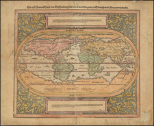
Shirley’s description
Shirley explains in his listing for map 560:
NICHOLAS DE FER, a prolific French cartographer, was active from the early 1690s until his death in 1720. He produced this outstanding four-sheet world map in 1694. The map itself was engraved by Hendrik van Loon but the work's real merit lies in the decorative features which were designed and engraved with distinction by Nicolas Guérard.
The two hemispheres, as the expanded title relates, were constructed from observations made throughout the world by gentlemen of the Royal Academy of Sciences. Australia, Papua, New Guinea, Japan, and other uncharted areas have their coastlines faintly shaded. In the African interior de Fer records the imaginary rivers and mountain ranges of his predecessors. One source of the Nile is shown, correctly, as corning from Lake Tana in Ethiopia but the other main tributary reaches into the Sahara. Across the equatorial regions de Fer has placed this note: 'Better to leave this space blank rather than fill it with unknown and imaginary particulars '. Following Coronelli, Chaumont's route from Brest to Siam and back in 1685-86 is marked, as is Schouten's track across the Pacific in 1616.
The top and bottom borders are engraved in great detail. Along the top are pictures of Saturn, Jupiter, Mars, Venus and Mercury after Cassini, and two visual plans of the sun and moon. An expansive tableau displays gods and goddesses, zodiacal figures, winds and mythological scenes. The lower part of the map has scenes depicting mankind in all activities of trade, commerce, exploration, construction, scientific discovery, art and pleasure.
There are two copies of de Fer's map in the Bibliotheque Nationale and another in the Bayerische Landesbibliothek, Karlsruhe [sic.]: others may be located elsewhere but I do not know of a copy in any of the public collections either in the UK or the USA. An issue of 1705 has been noted. The author possesses a copy dated 1717 but with accompanying text concluding with the date 1712, and there may also have been an edition of 1720. Later versions dated 1730 and 1737 were issued by de Fer's son-in-law Guillaume Danet, and in these states California has been redrawn as a peninsula, a fleet of ships offshore erased, and other amendments made to the plates. One such issue was exhibited by The Map House, London, in mid-1980 with text dated 1728 and in the dedicatory panel the imprint: Renouvellee et augmentee par les soins du G.Danet Gendre de l'Auteur et se rend chez lui pont N.Dame a la sphere Royale avec Privilege du Roi 1730.
Rarity
As noted in the Shirley description, this is an extremely rare map. This is only the fourth known example of this first state, in addition to the two noted in the Bibliotheque Nationale and the Badische Landesbibliothek, Karlsruhe.
Added to those later examples mentioned by Shirley, we note a very rare edition of 1698. It is nearly identical to the 1694, but with text panels at the sides of the map. An example of this state of the map was offered at auction by Reiss & Sohn in April 2004.
This strait, believed to separate northwestern America from northeastern Asia, was related to the centuries-long quest to find a Northwest Passage connecting the Atlantic Ocean to the Pacific. The rumor of this strait and a Northwest Passage in general inspired many voyages of discovery, including those of John Cabot, Sir Francis Drake, Gaspar Corte-Real, Jacques Cartier, and Sir Humphrey Gilbert.
The term Anian itself comes from Marco Polo’s thirteenth-century accounts of his travels. Polo used the term to refer to the Gulf of Tonkin, but cartographers thought it could refer to this supposed strait between Asia and North America. The Strait of Anian, so named, first appeared in a 1562 map by Giacomo Gastaldi, and was later adopted by Bolognini Zaltieri and Gerard Mercator.
The popular misconception of California as an island can be found on European maps from the sixteenth through the eighteenth centuries. From its first portrayal on a printed map by Diego Gutiérrez, in 1562, California was shown as part of North America by mapmakers, including Gerardus Mercator and Abraham Ortelius. In the 1620s, however, it began to appear as an island in several sources. While most of these show the equivalent of the modern state of California separated from the continent, others, like a manuscript chart by Joao Teixeira Albernaz I (ca. 1632) now in the collection of the National Library of Brasil shows the entire western half of North Americas as an island.
The myth of California as an island was most likely the result of the travel account of Sebastian Vizcaino, who had been sent north up the shore of California in 1602. A Carmelite friar, Fray Antonio de la Ascensión, accompanied him. Ascension described the land as an island and around 1620 sketched maps to that effect. Normally, this information would have been reviewed and locked in the Spanish repository, the Casa de la Contratación. However, the manuscript maps were intercepted in the Atlantic by the Dutch, who took them to Amsterdam where they began to circulate. Ascensión also published descriptions of the insular geography in Juan Torquemada’s Monarquia Indiana (1613) (with the island details curtailed somewhat) and in his own Relación breve of ca. 1620.
The first known maps to show California as an island were on the title pages of Antonio de Herrera’s Descripción de las Indias Occidentales (1622) and Jacob le Maire's Spieghel Der Australische Navigatie (1622). Two early examples of larger maps are those by Abraham Goos (1624) and another by Henry Briggs, which was included in Samuel Purchas’ Hakluytus Posthumus or Purchas his Pilgrimes (1625). In addition to Briggs and Goos, prominent practitioners like Jan Jansson and Nicolas Sanson adopted the new island and the practice became commonplace. John Speed’s map (1626-7), based on Briggs’ work, is well known for being one of the first to depict an insular California.
The island of California became a fixture on mid- and late-seventeenth century maps. The island suggested possible links to the Northwest Passage, with rivers in the North American interior supposedly connecting to the sea between California and the mainland. Furthermore, Francis Drake had landed in northern California on his circumnavigation (1577-80) and an insular California suggested that Spanish power in the area could be questioned.
Not everyone was convinced, however. Father Eusebio Kino, after extensive travels in what is now California, Arizona, and northern Mexico concluded that the island was actually a peninsula and published a map refuting the claim (Paris, 1705). Another skeptic was Guillaume De L’Isle. In 1700, De L’Isle discussed “whether California is an Island or a part of the continent” with J. D. Cassini; the letter was published in 1715. After reviewing all the literature available to him in Paris, De L’Isle concluded that the evidence supporting an insular California was not trustworthy. He also cited more recent explorations by the Jesuits (including Kino) that disproved the island theory. Later, in his map of 1722 (Carte d’Amerique dressee pour l’usage du Roy), De L’Isle would abandon the island theory entirely.
Despite Kino’s and De L’Isle’s work, California as an island remained common on maps until the mid-eighteenth century. De L’Isle’s son-in-law, Philippe Buache, for example, remained an adherent of the island depiction for some time. Another believer was Herman Moll, who reported that California was unequivocally an island, for he had had sailors in his offices that claimed to have circumnavigated it. In the face of such skepticism, the King of Spain, Ferdinand VII, had to issue a decree in 1747 proclaiming California to be a peninsula connected to North America; the geographic chimera, no matter how appealing, was not to be suffered any longer, although a few final maps were printed with the lingering island.
Nicholas de Fer (1646-1720) was the son of a map seller, Antoine de Fer, and grew to be one of the most well-known mapmakers in France in the seventeenth century. He was apprenticed at twelve years old to Louis Spirinx, an engraver. When his father died in 1673, Nicholas helped his mother run the business until 1687, when he became the sole proprietor.
His earliest known work is a map of the Canal of Languedoc in 1669, while some of his earliest engravings are in the revised edition of Methode pour Apprendre Facilement la Geographie (1685). In 1697, he published his first world atlas. Perhaps his most famous map is his wall map of America, published in 1698, with its celebrated beaver scene (engraved by Hendrick van Loon, designed by Nicolas Guerard). After his death in 1720, the business passed to his sons-in-law, Guillaume Danet and Jacques-Francois Benard.
![[ World ] Mappe-Monde ou Description Du Globe Terrestre . . . 1782](https://storage.googleapis.com/raremaps/img/small/103395.jpg)
![World [Rand, McNally & Company's Indexed Atlas of the World]](https://storage.googleapis.com/raremaps/img/small/100314.jpg)