|
||

|

|
|

|
Stock# 73127
Description
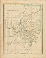
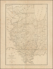
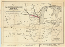
Early example of Tanner's map of Illinois, published in Philadelphia.]
The map is hand colored by counties, and shows canals, railroads, towns, roads, distances, and tables with steam boat routes and distances. The county configuations are largely complete. Inset of the Lead Region of Wisconsin and Northwestern Illinois are shown in a large inset.
Tanner's New Universal Atlas became the standard work in the Industry until Tanner sold the rights to the atlas in 1846 to SA Mitchell. The early editions are well regarded for the high quality paper and fine engraving, comparable to the American Atlas. Tanner's Universal Atlas is now rare on the market and the separate maps are now increasingly difficult to obtain.
Condition Description
Tear to the right side of Lake Michigan, repaired on verso with archival tape.