


|
||

|

|
|

|
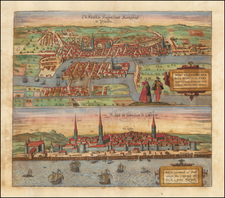
Gorgeous Wall Map of the Russian Imperial Capital.
Exceptionally detailed and beautiful Russian-language wall map of St. Petersburg, prepared in the late 1880s by the Hydrographic Department of the Marine Ministry, on the basis of the work of retired Colonel M.S. Vortonikov.
The map shows the city in incredible detail, with many large and public buildings rendered individually and groundcover meticulously mapped in a pleasing semi-pictorial style. It shows the extension of the city south beyond the previous limits of the Obvodny Canal.
The map is based on General Schubert's 1828 25-sheet survey map of St. Petersburg, which has been called "the largest publicly available map ever published of the city."
Because of the emancipation of the serfs in 1861, the city grew considerably in the period leading up to the creation of this map. By that time it had surpassed Moscow in population and industrial capacity, with large lower-income neighborhoods sprouting up almost spontaneously on the outskirts of the city.
Rarity
We find another example of the map having been offered on a Russian second-hand book site, though no details about the selling price are available.
![(Russian Language FIFA World Cup Poster) 14 й- ЧЕMПИОНАТ МИРА по ФУTБОАУ | Italia '90 [14th Soccer World Championship]](https://storage.googleapis.com/raremaps/img/small/89589.jpg)
![[Russia] Generalis Totius Imperii Moscovitici Novissima Tabula Magnam Orbis Terrarum partem a Polo Arctico usq[ue] ad mare Iaponicum, et Chinae Septentrionalis confinia exhibens cum Viz Czaricae nuper Legationis ex urbe Moscua per universum Tartariam ad magnu[m] Chinae Imperateruem ex conatibus . . .](https://storage.googleapis.com/raremaps/img/small/65778.jpg)
![[Ukraine, Russia] Asiae II Tab:](https://storage.googleapis.com/raremaps/img/small/89178.jpg)