|
||

|

|
|

|
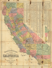
The Official General Land Office Map of California for 1879
Fine large map of California, published by the General Land Office in 1879.
This is one of the largest and most up-to-date maps of California in the late 1870s, showing Land Grants, Land Offices, Township Surveys, Military Reservations, Private Grants, Railroads, Indian Reservations and many other details.
One of the more interesting features is the demarcation of prospective Railroad lines, including the 20 or 30 mile limits granted to the railroads in order to induce and fund construction of the railroad lines.
The map includes a list of over 500 private land grants which have been approved by the United States and the State of California, representing the conversion of Spanish and/or Mexican land grants and ranchos to property ownership recognized by the United States and the State of California.
At the bottom of the land grant table, a list of 28 "Reservations" is shown, representing the Military, Naval, Light House and other lands claimed in California, including Indian Reservations for Round Valley, Hoopa Valley, Tule River, Colorado and two for the Mission Indians.
Rarity
The map is scarce on the market, especially in nice condition.