


|
||

|

|
|

|
A Los Angeles Rarity
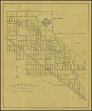
Fine early separately published map of Los Angeles, published by Oliver & Haines, Stationers, at 106 South Spring Street, Los Angeles.
This is one of the earliest printed maps of the City of Los Angeles to employ the use of color.
The map is centered on the Plaza, with circles radiating outward to illustrate distances from the City Center. China Town is prominently shown immediately east of the Plaza and Alameda Street. L.A. Grande Station is noted a bit further south.
The map shows the city of Los Angeles, with Slauson Ave. as the southern border, Arlington and Western Ave. to the west, Westminster Ave. to the east. he map shows streets, parks, rivers and other water features.
Rail lines are shown in red.
The Mutual Label & Lithographic Co. Los Angeles office was established sometime in the 1880s. Following the San Francisco earthquake in 1906, the company changed its name to Schmidt Lithograph Company. Oliver & Haines were active from about 1898 to 1908. Kitts & Jefferies, who printed the covers, was active from about 1895 to 1903.
Rarity
The map is extremely rare. We note only the example at the Huntington, which has been annotated to add transit lines.
![San Bernardino County [and:] Southwest Portion of San Bernardino County](https://storage.googleapis.com/raremaps/img/small/96727.jpg)