![[Untitled Map of The Atlantic Ocean, Europe, Africa, the Middle East, and Eastern Canada] By Domenico Zenoi / Orazio Bertelli](https://storage.googleapis.com/raremaps/img/small/89582.jpg)


|
||

|

|
|

|
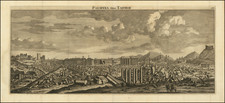
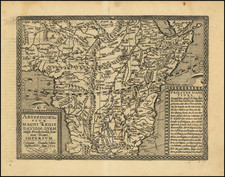
One of the First Appearances of Forlani's Canadian Cartography.
Rare Lafreri School map covering Africa, Europe, the Middle East, and the northeast coast of North America, engraved by Oratio Bertelli for Domenico Zenoi and first published in 1570.
The treatment of the northeastern part of Canada is of note. "Terra De Bacalos" (Land of Codfish) is noted, along with a number of other early place names. The name "Mare Della Nova Franza", also appears. These names suggest that the cartographic source of this map is either Forlani's 1565 map of North America ( Il Disegno del discoperto della nova Franza) or Camocio's untitled wall map, which Burden originally dated circa 1569 (Burden 37), but which Woodward and Burden now believe was published circa 1575 (See Burden II, #44a). Regardless of the source, this is among the earliest maps to incorporate Forlani's revised treatment of the region.
The map also includes an early configuration of the British Isles. Iceland is completely omitted. The shape of Scandinavia is very primitive. The Atlantic is filled with islands, some of which are mythical.
Rarity and States
Per Burden II (41a) and Bifolco/Ronca (226) there are 3 states of the map:
- The map originally appeared in 1570, at which time it included a dedication to Francesco Scaridino.
- In the second state, the dedication is removed.
- In the third state, the rhumb lines are removed and the plate number "2" is added at the top right corner.
The map is of sufficient rarity that it did not appear in the first edition of Burden's The Mapping of North America, eventually appearing in the supplemental section in The Mapping of North America II.
The map is often attributed to Giovanni Francesco Camocio because of its inclusion in the Isole Famose Porti, Fortezze e Terre Maritime . . . , a book of maps and prints of the Dalmatian Coast and Aegean sea, which normally lacks the title page and when present, there is no publisher given. As noted by Burden, because a number of the maps are signed by Camocio, he is often credited with the publication of this map, despite the Zenoi credit in the dedication cartouche in the first state of the map.
![[St. Pierre Island] Carte De L'Isle Saint Pierre Dressee au Depost des Cartes et Plans de la Marine . . . Par Ordre de M. Le Duc de Choiseul . . . M DCCLXIII](https://storage.googleapis.com/raremaps/img/small/80010.jpg)