|
||

|

|
|

|
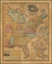
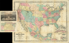
One of the First Wall Maps of the United States Published in Europe
Fine example of Cassini's scarce six-sheet wall map of the United States, published in Rome in 1797.
The map extends just west of the Mississippi River, as far south as the Florida Keys, north to James Bay (part of Hudson Bay), and east to Nova Scotia (an inset shows Newfoundland and Labrador).
The map is drawn from the late editions of John Mitchell's map of North America, but with some fascinating additions. Most notably, the map includes a number of Forts in Pennsylvania which do not appear on Mitchell's map.
Cassini's map is a fascinating amalgam of up-to-date information and curious errors. Generally, it derives from John Mitchell's A Map of the British and French Dominions in North America... However, changes have been made, for instance, Cassini's map extends farther to the south
The map is rich with information, and there is much to be studied. For instance, it includes an 18th-century mention of the Port of Chicago "Fiume e Porto Chicagou".
In the south, the map includes several curious errors.
- "Luigiana" (Louisiana) is shown on both sides of the Mississippi River
- Georgia appears in the middle of Carolina Meridionale (South Carolina)
- Carolina Settentrionale (North Carolina) still extends to the Mississippi River
- Florida extends into Georgia and the soon to be named Mississippi Territory
- Tennessee is apparently named Cherakesi (Cherokee)
Rarity
While the individual Cassini map sheets appear on the market. Complete and assembled copies of the 6 sheet map are quite scarce.