This item has been sold, but you can enter your email address to be notified if another example becomes available.


|
||

|

|
|

|
Stock# 72421
Description
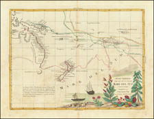
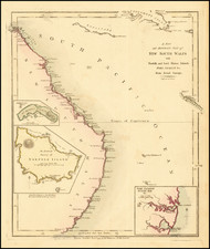
One of the Earliest Commercial Navigation Maps of Cook's Strait
Rare and finely colored map of Cook's Strait, published in London by John Luffman.
The map shows the early names for the two islands (Tavai Poe Nammoo and Eahei No Mauwe), along with a number of place names and soundings.
Predates Wellington.
Rarity
The Luffman maps are very rare on the market. This is the first example of the map we have ever offered.
Condition Description
Original publisher's color.