|
||

|

|
|

|
Stock# 72380
Description
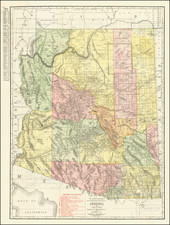
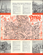
Early postal map of Arizona, published 13 years after Arizona Statehood.
The map identifies Post Offices, County Seats, discontinued post offices, and towns without a post offices.
The route lines show the routes services once a week, twice a week, three times a week and six times a week, with the beginning and ending points of routes shown. Rural Delivery, Special Supply and Mail Messenger routes are shown.
Other details include railroad lines and stations and electric railroads.
![[ Southwest & Texas ] Le Nouveau Mexique, Avec La Partie Septentrionale De L'Ancien, ou De La Nouvelle Espagne](https://storage.googleapis.com/raremaps/img/small/99395.jpg)