|
||

|

|
|

|
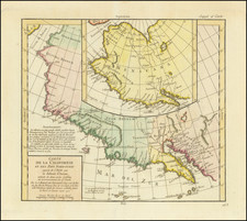
One of the Earliest Maps of the Oregon Coast—Port Sidman (Winchester Bay)
Fine Spanish manuscript chart of Sidman Bay, one of the earliest detailed charts of the Oregon Coast.
Sidman Bay, today called Winchester Bay, located at the mouth of the Umpqua River, was first charted by the Jenny, a Bristol merchant vessel trading for furs in the Pacific Northwest from 1792-1794. The captain of the Jenny shared his information with the Vancouver expedition, who then passed it to the Spanish.
This is a presentation copy of the chart, likely prepared as part of an atlas for submission on behalf of Don Juan Francisco de la Bodega y Quadra to the Dirección Hidrográfica in Cadiz.
The chart is oriented to the east, showing the inlet as it would appear from the coast. A line of sounding depths marks the entrance, with an anchorage place at their terminus. Nearby are a grouping of x marks that denote sailing obstructions. The title, in the upper right corner, reads:
Plan of Port Sidman situated in the Latitude N. 43°56’ Longitude 19° to the W[est] of San Blas examined this year by Captain Baker
Captain Baker was in command of the Jenny, which was owned by Sydenham Teast, a Bristol merchant. Baker named the feature for his patron.
Early European encounters on the Oregon Coast—imaginative mappings and initial interests
Europeans attempted to map the Pacific Northwest long before they actually visited the area. Most early depictions of the region use it as a staging ground for a passage, the Strait of Anian, or a river or inland sea that might connect Atlantic to Pacific. For example, the 1582 Illustri Viro Domino Phillippo Sidnaeo Michael Lok shows a passage in roughly 45°-48°N latitude. The Pacific Northwest was also the supposed location of various specious, yet tantalizing, straits such as those of Martin Aguilar, Juan de Fuca, and Admiral de la Fonte.
Although nominally controlled by the Spanish, the colonizers of Mexico seldom sailed farther north than the California coast. Instead, they focused on the Acapulco-Manila treasure galleon loop that was established in 1565 and continued until 1815. However, ships did sometimes go astray. The Beeswax Wreck, so called because the cargo contained tons of beeswax and candles, as well as Chinese porcelain and other goods, is a wreck that was located on the Nehalem Spit and was first reported by fur trader Alexander Henry in 1813. Radiocarbon dating and historical records indicate that this was most likely the Santa Cristo de Burgos, which left Manila in 1693 and then disappeared, becoming one of the Pacific Northwest’s earliest European shipwrecks.
Following the third voyage of James Cook (1776-1780), Europeans and Americans hurried to cash in on the lucrative fur trade in sea otter, beaver, and other animal pelts. The Russians had been coming to Alaska periodically for pelts since the 1740s and they set up their first permanent settlement in 1784. Around the same time, fur traders began arriving by sea; James Hanna, of the Harmon, is often cited as the first, arriving in Nootka Sound in 1785. Within a year, several other commercial ships had also visited the site.
Early European encounters on the Oregon Coast—Spanish voyages in the Pacific Northwest, 1774-1793, and the settlement of Nootka Sound
The Spanish, meanwhile, had reinvigorated their interest in the northwestern coast of North America as they heard reports of Russian encroachment and imminent British voyages. Their first voyage set out in 1774, commanded by Juan Pérez. He led the Santiago north to the southern tip of Vancouver Island, then thought to be part of the mainland. However, he never landed or formally claimed land on behalf of Spain. He turned back at Haida Gwaii, ending the first confirmed voyage of Europeans to the Pacific Northwest.
A year later, Bruno de Heceta commanded a second expedition in the Santiago. He followed Pérez’s route north, in company with the Sonora and San Carlos. The Sonora was a small schooner intended to be able to get close to the shore for charting and surveying. This hydrographic vessel was commanded by Juan Francisco de Bodega y Quadra. The San Carlos was the first European ship to enter San Francisco Bay. The other two vessels continued north, but Heceta was forced to return to San Blas due to illness among his crew. On his return trip south, Heceta noted the mouth of the mighty Colombia River, which was named on Spanish charts as the Entrada de Ezeta. Bodega y Quadra, now alone, took the Sonora to 59°N latitude. He sailed into Sitka Sound and performed many acts of sovereignty along the way, claiming the land in the name of the Spanish Crown.
In 1779, Ignacio de Arteaga, in command of the Princesa, sailed with Bodega y Quadra in the Favorita. The ships were supposed to evaluate the expansion of the Russian fur enterprise in Alaska, as well as to capture James Cook if he was found in Spanish waters. They were also, of course, supposed to keep an eye out for the elusive Northwest Passage. They did not find Cook, but they did sail to 61°N latitude, the farthest north of the Spanish voyages.
By the time of the third voyage, Spain was at war with Britain. The Viceroy of New Spain decided to suspend the voyages until peace was achieved and the imperial coffers replenished. The next voyage sailed nearly a decade after the third, in 1788, again to see the extent of Russian activity in Alaska. The Princesa, this time commanded by Esteban José Martínez, and the San Carlos, under Gonzalo López de Haro, sailed to Prince William Sound. They found the Russian posts and made contact at Three Saints Bay, the first Spaniards to do so. They also visited Unalaska, the farthest west reached by the Spanish Pacific Northwest voyages.
While on the 1788 expedition, the Spanish heard that the Russians had their sights set on Nootka Sound, a port the Spanish had visited and claimed. With Martínez and Haro again in command, they were supposed to ensure that Nootka Sound stayed in Spanish hands. They found that the area was already visited by British ships participating in the fur trade; indeed, when they arrived there were already two American ships and one British ship in the Sound. The latter, the Iphigenia, was seized and then released several days later, with orders to flee. Another vessel, the North West America, was also seized and turned into a Spanish ship, the Santa Gertrudis la Magna, which José María Narváez used to explore the Juan de Fuca Strait. Martinez continued to challenge non-Spanish ships and commanders in the summer of 1789.
Over the next two years, and after a change in regime that ousted Martínez and brought in Bodega y Quadra, the Spanish built up a base at Nootka Sound, forming the first European settlement in what is today British Columbia. In summer 1790, Salvador Fidalgo was sent north to claim more Alaskan land for Spain; he named Cordova Bay and Port Valdez.
At the same time, Manuel Quimper was sent south from Nootka; he followed the route of Narváez into the Juan de Fuca Strait and explored among the San Juan Islands. Francisco de Eliza was the next to investigate the Juan de Fuca Strait, in 1791. He was accompanied in the San Carlos by Narváez in the Santa Saturnina. They explored the Strait of Georgia.
While the Spanish base at Nootka had proven useful for exploration, it was still controversial. Alejandro Malaspina, on his global voyage, visited Nootka for a month; he regained the trust of a local leader, Maquinna, and was promised that the Spanish had the rightful claim to land at Nootka Sound. In mid-1792, Bodega y Quadra arrived in Nootka to negotiate the second Nootka Convention; the British sent George Vancouver, who was on a Pacific voyage of exploration.
Early encounters with the Oregon Coast—the naming and mapping of Port Sidman (Winchester Bay) and the Nootka Sound Convention of 1792
One of the merchants eager to enjoy the wealth of the fur trade was Sydenham Teast. Teast owned several ships, most of which were whalers. He also traded with Africa, including as part of the slave trade. One of his ships, the Jenny, had previously transported enslaved people to Barbados. In early 1791, the ship was fitted out for a long voyage and set out “for Cape de Verde and the South seas” (Felix Farley’s Bristol Journal, June 18, 1791).
Commanded by James Baker, the Jenny made its way across the Pacific to Rapa Nui (Easter Island), Tahiti, Christmas Island, and then Hawai’i. In Tahiti Baker had picked up several members of the shipwrecked crew of the Matilda. In Hawai’i, he added two local women to his complement. Next, the Jenny headed for the Pacific Northwest, reaching Clayoquot Sound, on the west coast of Vancouver Island, by August 7, 1792.
It was on the Jenny’s way north to Vancouver Island—most likely in June or July—that the ship encountered and charted Port Sidman. Baker traded with the local people, who were most likely of the Coos Tribe or the Quuiich Band of the Lower Umpqua Tribe. The incident was reported in the journal of another captain in Teast’s employ, Captain Bishop of the Ruby, written during his own Pacific Northwest trading trip in 1794:
This morning after a night of light winds with intervals of calm and rain we found ourselves off Port Sidenham, a small river which has a bar at its entrance. . . . Captain James Baker of Mr. Teast's ship the Jenny in his voyage of 1791 fell in with this place and went in safe when he continued trading with the natives ten or twelve days, but procured few otter skins. . . . Captain Baker not knowing that it had ever been visited by any other vessel called it Port Sidenham, in honor of Mr. Sidenham Teast his spirited commercial owner.
The encounter between Baker and the local peoples was one of the first commercial interactions on what is now the Oregon Coast. Only a few weeks prior, however, on May 11, 1792, the Boston ship Columbia Rediviva, under Captain Robert Gray, had made it over the bar and into the mouth of the large river, calling it after the ship, the Columbia.
Meanwhile, also in 1792, Malaspina sent two of his officers, Dionisio Alcalá Galiano and Cayetano Valdés y Flores, to survey Vancouver Island in the goletas Sutil and Mexicana. They became the first Europeans to circumnavigate Vancouver Island, on which Nootka Sound lies. En route, they met George Vancouver, who was also then surveying in the area. In the same year, Jacinto Caamaño surveyed the southern coast of the island; his maps were shared with George Vancouver, who adopted many of his Spanish place names.
Into this busy scene sailed the Jenny, which arrived at Nootka Sound in early October, just after Bodega y Quadra had sailed south. Vancouver was still in the port, readying his ships. According to Vancouver’s account, Baker persuaded the British navigator to take on the two Hawai’ian women, as Baker would be returning to England and could not escort them back to their home islands.
The Jenny arrived just after Vancouver and Bodega y Quadra had finished their negotiations. The two had met for several weeks but could not decide on boundaries and settlements; they referred the matter back to diplomats in Europe, but only after agreeing to meet again, at the end of 1792, in Monterey, California.
The Jenny soon sailed back south for, as Vancouver’s accompanying vessel, Chatham, made it over the bar into the Columbia, they sighted the Jenny already there. Indeed, Baker Bay, at the mouth of the river, is named for the Jenny’s commander. It is possible that Baker had already given Vancouver a copy of this map when he was in Nootka; otherwise, he likely handed it over to Lieutenant William Robert Broughton in the Chatham. Broughton then sailed to Monterey, where Vancouver was meeting for a second time with Bodega y Quadra, and it is in Monterey that this map was most likely handed over to the Spanish.
Based at least in part on maps like this one, the Spanish decided they needed to not only understand the coast from Vancouver Island to Alaska, but also the area between San Francisco Bay and the Juan de Fuca Strait. To this end, in 1793, the Viceroy of New Spain sent Eliza and Juan Martínez y Zayas to survey this stretch of coast, connecting the Spanish claims. Interestingly, Zayas searched for Port Sidman but reported that he could not locate it. This was the first Spanish voyage to spend any considerable time on the Oregon Coast, but they still did not land anywhere for a sustained period of time.
Rarity
This is the only known example of this manuscript chart. The title of a similar chart is mentioned in the Boletín de la Sociedad Mexicana de la Geografia y Estadística as part of the plans included with the journal of Bodega y Quadra from his 1792 expedition to Nookta. This map was likely part of a presentation atlas prepared in clean copy for the authorities in Spain.
The manuscript atlas to which the map belonged must have been broken up sometime in the twentieth century. At least three other maps from the same atlas, with the same numbering convention, have been introduced to the market in the last decade.
We locate only one earlier high-resolution chart of the Oregon Coast, a 1775 plan of the mouth of the Columbia River. This is the earliest extant chart known for Winchester Bay or any area of the Oregon Coast south of the Columbia.
![(Canadian-American Boundary) [Group of 11 photographs by Alexander Gardner, including 3 after the British Commission's 1860-61 photographs, for the North American Boundary Commission Survey along the 49th Parallel, used in settling Hudson's Bay Co. claims in the British and American Joint Commission]](https://storage.googleapis.com/raremaps/img/small/95481.jpg)