|
||

|

|
|

|
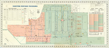
Extremely Important Los Angeles Rancho Manuscript Partition Survey Map. Owned by John Rowland and H.J. Stevenson.
Original survey of the lands of famed California pioneers John Albert Rowland and William Workman, representing a large section of southeastern Los Angeles County, executed by Los Angeles County Surveyor George Hansen in 1868.
The present map is the original partition survey map of Rancho La Puente, undertaken by George Hansen from 1866 to 1868. Following the annexation of California by the United States, the Treaty of Guadalupe Hidalgo required that landowners claiming title under Spanish and Mexian land grants would be respected. A process (described below) was established by Congress in 1851. The original rancho holders, Rowland and Workman, undertook a 15 year legal fight, which finally saw the land confirmed to them in 1866.
The present map is the survey map was sets forth the first partitioning and subdivision of the Rancho, allowing it to be sub-divded among its two founders and several family members and others to whom portions of the Rancho had been transferred over the years.
The map covers much of the present-day communities of Hacienda Heights, Rowland Heights, Walnut, Diamond Bar, City of Industry, and West Covina, and it is a foundational cartographic document for the region. This survey was a direct result of the establishment of California as a state, and of the Act that was created to transfer Spanish-Mexican land grants into private ownership under the laws of the State of California.
On this map, the "Dwelling of W. Workman" and "Dwelling of John Rowland sen." ("& Victoria & Albert R." added in pencil) are shown not more than a short walk from one another in the San Jose Valley. John Rowland's Mill is also located. Workman's dwelling includes a separate Chapel and to the north, a note marked simply "Ruin".
Further south, the Rowland's Pass to Anaheim and the Workman's Road to Anaheim Landing are shown in the Rancho Paseo de Bartolo, along with the Milch Ranch and Coral. At several points on the map, the road to Anaheim is noted. Anaheim was founded by fifty German families in 1857 and incorporated as the second city in Los Angeles County on March 18, 1876. At the time the map was drawn, Anaheim was the largest Wine producing region in California.
To the west, Workman's Mill and the Sheep Ranch of Temple are noted. This is may be the "rude sheepherder's hut" on a corner of a rancho where Pliny Fisk Temple, at one point one of the wealthiest men in California and William Workman's son-in-law and partner, died in 1880.
The map depicts the The "House of Wheat Rancho of Workman" and a neighboring spring. It is known that during the Mexican period the Rancho was used by the San Gabriel Mission fathers for wheat raising as well as stock pasturage. By the 1870s, wheat and vineyards were two of the primary cash crops for William Workman. At least one sheep coral is also noted.
A number of other minor surveys are noted in a light pencil including:
- Lambou?? 0.4 acres
Other landowners noted on the survey include:
- John Reed (several places)
- Joseph M. Workman
- William Rowland
- John Rowland Junior
- Thomas Rowland
- Andres Martinez
- Sisto
- Sant. Martinez
- Juan Martinez
- Inocente Martinez
- Garcias
- Velaredez
- A. Quentano
- Jose Martinez
- Coral of P. Chavis
- Antonio Brito
- "House of Wheat Rancho of Workman"
The map's depiction of dozens of early buildings and dwellings, all labeled with their owners or inhabitants, substantially enriches the research value of the map.
The map bears the signatures of both John Rowland and Henry (H. J.) Stevenson. This example of the map likely began as the property of John Rowland, before being passed on to Los Angeles County Surveyor Henry John Stevenson sometime after 1874.
1851 Act to Settle Private Land Claims in California
Immediately after the creation of the State of California, legislation was needed to ascertain and settle private land claims within its territory. The lands in question had been acquired by means of Spanish-Mexican land grants, as is the case with the Rowland and Workman lands shown here. The Act set procedures for claimants to present their claims. Patents were to be issued for lands when claims were confirmed. All claims confirmed were to be accurately surveyed. All lands for which claims were not established were to be taken as public lands.
Rancho La Puente / John A. Rowland (1791–1873) & William Workman (1802–1876)
John Rowland and William Workman were two of the most important early settlers of the Los Angeles metropolitan area.
Rowland was trained as a surveyor before making his way to Taos in the 1820s, where he became a fur trapper. There he met William Workman, with whom he formed a long-lasting friendship and business partnership. Rowland and Workman were active in the politics of Alta California, which at times left them on the wrong side of local authorities. In 1841, under threat of invasion from Texas (an invasion that eventually failed), Rowland and Workman led a party of New Mexicans west along the Old Spanish Trail to what is now Southern California.
In early 1842, Rowland (usually referred to as "John Roland" or "Juan Roland" in the land grant records) petitioned in his name alone for a land grant and received preliminary possession of the 11,740-acre Rancho La Puente.
Possibly with the grant preliminarily secured, Workman remained at La Puente while Rowland returned, in April 1842, to New Mexico to retrieve his family. They and other immigrants traveled to California and arrived the same year at Los Angeles in December. By the next summer, Rowland constructed an adobe home about a mile east of Workman's built the previous year. They set about improving the land as stipulated in the grant and probably engaging in the hide and tallow trade.
In 1847, Rowland built the first private grist mill in the Los Angeles region, not far east of his home (shown on this map as "Mill of John Rowland"). Rowland must have been doing well with his cattle, crops, orchards, and vineyards as he exhibited at a California State Fair in the early 1850s a sheave of wheat. Rowland and Workman both sold part of their grape crops to the winemakers Kohler and Frohling. By the early 1860s success was enough to impress a touring correspondent that visited Workman's place seeing cattle and horses as well as vineyards and orchards. Rowland was in a good position with the San Jose River running through the grant. It was possible for Rowland to transition from the boom of the 1849 Gold Rush from a livestock-based agrarian environment to include all types of fruits and vegetables.
About 1851, Rowland and Workman informally divided the grant, with Rowland taking about 29,000-acre in the east portion and Workman receiving the 20,000-acre western part. Rowland and Workman entered their claim to the Land Commission on October 9, 1852. By 1854, the commission validated the shared claim. The U.S. government later appealed the decision made by the Land Commission and challenged the size of the original land grant which had been 18,000 acres in 1842, extended to 48,000 acres in 1845. The U.S. District Court ruled on December 1856 that the 1845 land grant issued by Pico was “good and valid;” yet, the court decreed “that the claim could be no larger than eleven square leagues [a league being 4428.4 acres], customary for Mexican landgrants."
To affirm property lines, a land survey was conducted of the rancho and was submitted to the commissioner of the General Land Office in August 1859. The 1857 land survey, conducted by Henry Hancock, retraced the same basic rancho boundary as in the 1842 diseño made by Isaac Given for the Mexican government.
Rowland contacted Henry W. Halleck, Abraham Lincoln's Chief of Staff, who had served as California Secretary of State and who had submitted one of the two reports to Congress about the viability of California private land claims, for advice on obtaining his patent. Halleck's 1865 response was brief, but to the point: "hire a lawyer and give him plenty of money." This Rowland did, hiring attorney Henry Beard, who prepared a published synopsis of the land claim in 1866 and who was successful in securing the patent. The La Puente Grant was patented on April 19th, 1867 and a final survey was completed in by George Hansen in 1868.
The Temple-Workman Family
Jonathan Temple (1796-1866) lived in Hawaii and San Diego before opening the first American-style store in Los Angeles in 1828, which he operated for almost thirty years. In 1843, he purchased the Rancho Los Cerritos, a 27,000-acre property in today's Long Beach area. The Workman and Temple families were united when Jonathan's brother Pliny Fisk Temple married William Workman's daughter Antonia Margarita Workman in September 1845.
In 1850, William Workman gave Rancho La Merced to his ranch foreman, Juan Matias Sanchez, and his daughter, Margarita, and her husband, P.F. Temple. Subsequently, with his son-in-law F.P. Temple and with Juan Sanchez, Workman acquired neighboring ranchos, including Rancho Potrero Grande, Rancho Potrero de Felipe Lugo, and Rancho Potrero Chico. By the 1870s, Workman and F.P. Temple were speculating in real estate, railroads, banking and early oil discoveries in the Santa Susana Mountains. A run on their bank in 1875 resulted in its being bailed out by Elias J. "Lucky" Baldwin, who shortly thereafter foreclosed on the interests of the partners.
The catastrophic reversals led to Temple's financial ruin. He died at age 58 of apoplexy. Some historians have claimed he died in a "rude sheepherder's hut" on a corner of the rancho, perhaps the one shown on the map.
Henry John Stevenson
H. J. Stevenson was a Civil Engineer and Surveyor, who rose to become Los Angeles County Surveyor and Los Angeles County Surveyor.
Canadian by birth, Stevenson attended Washington County Seminary and Collegiate Institute in New York from 1861-62. From 1862-64 he was a chainman and axeman for George House and George Sloan in Port Angeles. He received his own survey contract in Washington Territory in 1864. By 1869 he was in Portland, Oregon .Between 1869 and 1874, he worked as a surveyor, serving as Portland City Surveyor from 1869-1872.
By late 1874, he had relocated to Los Angeles and was advertising as a surveyor. He received an appointment as a U. S. Deputy Surveyor in California to examine improvements on Rancho Santa Monica in 1876. In 1879, Stevenson ran for State Surveyor General of California on the Workingman Ticket and lost.
From 1884-87 Henry was involved in speculative real estate development, selling acreage and lots. He suffered several business and personal foreclosures in 1888-89. By the late 1880s, Stevenson's fortunes had changed dramatically, as he apparently became the mastermind of a land fraud scheme which would become known as the "school-lands scheme." As described by the Los Angeles Times on March 10, 1888,
There is no denying the fact that there is something radically wrong, and hardly a day passes without letters being received by the Government land officials here, making inquiries about this and that section of land which has been located by parties in other sections of the State, which are shown by the maps to be in wild and impracticable mountains, lava beds or desert land, utterly worthless. The Register of the Land Office has received at least a hundred such letters in the past month . . .
Stevenson's scheme seems to have also employed the use of unwitting strawman agents, whom he persuaded to hold title to the land, before selling it to the ultimate victims. He was listed as a surveyor in the censuses in Los Angeles in 1900, 1910 and 1920, and was noted as surveying several large ranches into developments over the years in Southern California.
Santiago Martinez, etc.
Santiago Martinez constructed an important adobe home in the region. There were three families of Martinez's in the area. Of these Santiago was the best known. Coming to Los Angeles in 1842 with twenty families from New Mexico, they would be part of the settlement at Politana on the Rancho San Bernardino. In 1845 they had become discontented with this location and decided to relocate to La Jabonería. Unable to locate here, Santiago Martinez and several of these families settled in a group on land allotted them by John Rowland on the Rancho La Puente, which here formed part of the Township of San Jose.
Santiago Martinez prospered and became an influential man in the community. All went well with this colony of New Mexicans until after the death of John Rowland in 1873, when it was found they had no deeds to their homes, and the title to their lands was disputed. It was finally adjusted by allowing each family a few acres, but small in comparison to their original acre.
Provenance
Evidently, this was John Rowland's copy of the map, as it is signed by him, rather than Workman.
It is further inscribed "Property of Henry Stevenson, Surveyor" in the lower right corner (Stevenson was responsible for number of very important Los Angeles maps such as the 1884 Map of the City of Los Angeles California).
The map was acquired by wealthy Los Angeles-area physician and collector P.A. Foster sometime in the early 20th century, thence by descent in his family, from whom we acquired it in 2021.
![Map of Los Angeles and Suburbs Copyrighted 1906 by A. Humitsch [Map of Los Angeles... Issued by the German-American Savings Bank]](https://storage.googleapis.com/raremaps/img/small/92785.jpg)