|
||

|

|
|

|
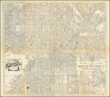
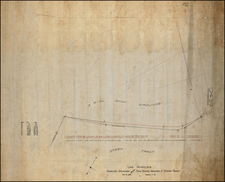
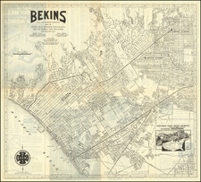
Manuscript Map Showing the Early Development of San Gabriel, Los Angeles
Crucial early manuscript cadastral map showing one of the first built-up communities in Los Angeles, the Mission San Gabriel Arcangel, completed by H.M. Johnston in May 1870.
According to our research, the present map is the only extant cartographic treatment of land ownership around the Mission San Gabriel Arcángel at this time. As one of the first organized, built-up communities in what is now Los Angeles, San Gabriel formed an important part of the loose matrix of settlement from which Los Angeles grew. Additionally, this map is a snapshot of the Mission in the decades before massive growth would begin to transform the metropolitan area and erase much of what had preceded.
The map's detailed accounting of the lands surrounding the Mission - naming lot owners, the size of lots, and more in this still little-developed area - is, as far as we have found, unrivaled for this period.
The old roads shown on the map roughly correspond to the intersection of South Mission Drive and South Santa Anita street next to the Mission. The map approximately stretches north to West Las Tunas Drive, east to Junipero Serra Drive, south just past the Mission, and west to just shy of the Alhambra Wash. This is now a primarily residential area which also includes several public and Catholic schools.
The map followed shortly after the official survey of the region which was approved by Sherman Day (Surveyor General of California) and accepted in January of 1870, and can be seen here. The official survey is here referenced under the main title, in red text. It states that "Lot 3 is laid down from the final government survey of the San Gabriel Mission lands." The completion of this survey was then complemented by the mapping of small plots at increased detail, as shown here. This official survey is referenced in the presented map as follows:
This survey was completed by Hancock Johnston, who produced surveys of the greater Los Angeles region into the 1880s. Three other Johnston surveys are held at the Huntington Library, which show the San Gabriel and Griffin Park areas.
Survey Details
The survey shows a small community, with the names of about 20 landowners shown, laid out on either side of a main road and "zanja," with the Mission San Gabriel Church shown at the bottom. The zanja (water ditch) shown was one of the earliest irrigation projects in California history. The small settlement which grew up around the Mission San Gabriel was centered on this zanja and the adjacent road, with virtually all of the structures on the map abutting the zanja and road, which is today's South Mission Drive. The zanja flowed from Mt. Wilson and San Pasqual Creek.
The home of Doctor D.F. Hall is also of interest. Today, this is the location of the San Gabriel Grape Arbor. The first grapes were brought to California for viticulture in 1768 by Junipero Serra. The second planting was at the Mission San Gabriel. This planting is widely regarded as the birthplace of California viticulture. By the last decade of the 18th century, Mission San Gabriel Arcángel was making 35,000,000 gallons of wine. In 1820, the wine made from Mission grapes began to be exported overseas. San Gabriel's Vineyard would come to be known as Viña Madre—"Mother Vineyard".
Further north is the land owned by William Money (1807-1881), on which he created a commune which he called the Moneyan Institite, based on common property and total obedience to Money. The buildings at the institute were designed to resist earthquakes—most were octagonally-shaped adobe with pyramidal roofs; the main house was ovular and aligned north-south "to 'ride out' the earthquakes," according to the book San Gabriel. Money was an outspoken critic of the Roman Catholic Church, the city's first documented cult leader and a quack doctor in Los Angeles, until his relocation to San Gabriel in 1857. His stunts included claiming that he could rise from the dead like Jesus Christ. Newspaper accounts describe him as a practitioner of "astrology, natural history, medicine, meteorology, theology, history and cartography". In 1857, Money moved to San Gabriel, where he designed and built a cluster of octagonal edifices of wood and adobe, including a double entrance gate with inscriptions in Greek, Latin and Hebrew. Although he had no medical degree, he claimed to have treated 5,000 ailing patients, of which "only four had died." Most of Money's followers were native Californians. He published a Spanish-language book on disease in 1858. Money’s life is chronicled in a 1943 booklet by William B. Rice, “William Money: A Southern California Savant.”
The San Gabriel Mission
The Mission San Gabriel Arcángel, founded by Junipero Serra in 1771, is known as the birthplace of Los Angeles. When the latter would be founded as a Pueblo in 1781, the two settlements would have to compete for indigenous labor, leading to early rivalry between the city and Mission.
In addition to being a spiritual center of southern California, the Mission provided a critical agricultural lifeline. By the early 19th century, the Mission was largely self-sufficient and provided food for the military and civil government of California. In 1834, however, many of the church's buildings were secularized due to political intervention by the Mexican government and subsequently fell into disrepair.
Following the occupation of the land by the state of California, the last Franciscan to occupy the Mission would withdraw in 1852. In 1855, however, the US Land Commission would return the land to the mission. This is shown on the official 1870 survey map,
The official 1870 survey map shows that the Mission still owned large amounts of land in Los Angeles into this period. Agriculture was still a large part of the surrounding community's industry, as shown on the presented map.
The arrival of the Union-Pacific Railroad to Los Angeles in the 1860s following California's admission to the union would revive the area around San Gabriel that had first prospered under the Mission.
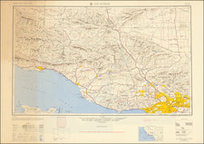
Los Angeles and San Gabriel in 1870
1870 formed the end of the early American era in Los Angeles. Following admission into the union, California was heavily resurveyed and US property law imposed. Manuscript survey maps then became indispensable for ascertaining land ownership and property rights.
1869 would herald the start of the railroad era in Los Angeles when the Los Angeles & San Pedro Line was completed. Connecting railroads would arrive in 1876, and this was the defining moment that changed Los Angeles from a center of speculation with an agricultural backdrop to a rapidly growing city. 1870 would be most notable for seeing the roots of the Chinese massacre of 1871 being planted with vicious editorials in local papers.
During this period, San Gabriel remained a small, agricultural center. The population in 1760 was 586 (about 10% of Los Angeles), and in the 1880s it would be described as--"a wild little town with eighteen saloons within a two-block area."
Rarity
Pre-1880s cadastral maps at this scale, covering organized communities in what is now the Los Angeles metropolitan area, are extremely rare. Furthermore, we have been unable to trace any similar cadastral maps for the Mission in any of the likely Los Angeles collections.
This map represents a vital nexus for understanding the communities that constituted the Los Angeles basin prior to its transformation into the modern megalopolis it is today.