


|
||

|

|
|

|
Home of the Last Mexican Governor of California
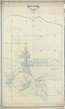
An exceptional large survey map of Rancho Paso de Bartolo, then home of Don Pio Pico, the last of the Mexican Governors of California and one of the most influential figures in the early history of Southern California.
The Rancho comprises includes present-day Montebello, Whittier, and Pico Rivera.
At the center of the Rancho, a group of buildings is shown as the "House of Don Pio Pico," along with a Chapel, Mill and other buildings, located on the "New River", referencing the newly changed course of the San Gabriel River in 1867.
Among the only other buildings shown on the map are a group of homes on a parcel labeled Ch. Strong. This would be the 320 acres of land purchased from Pio Pico by Charles and Harriett Strong in 1867. The Strongs built a 3 room adobe on the property, calling it Rancho del Fuerte. When Charles Strong died in 1883, Harriet Strong would go on to plant walnuts, which had just come into favor with California growers. She earned tremendous success which won her the names of "Walnut Queen". She would go on to become a social activist, inventor, conservationist, and leading figure of the early woman's movement. She has been inducted into the National Women's Hall of Fame and the National Inventors Hall of Fame. Her pioneering innovations in water storage and flood control enabled the construction of the Hoover dam and the All-American Canal.
Rancho Paso de Bartolo
Rancho Paso de Bartolo also called Rancho Paso de Bartolo Viejo was a 10,075-acre Mexican land grant in present-day Los Angeles County, California given in 1835 by Governor Jose Figueroa to Juan Crispin Perez. The Rancho is named for a crossing of the San Gabriel River called Paso de Bartolo Viejo (Old Bartolo's Crossing). The rancho includes present-day Montebello, Whittier, and Pico Rivera.
Initially property of the San Gabriel Mission, the Rancho Paso de Bartolo land became a part of the original 300,000-acre (1,200 km2) Rancho Los Nietos grant. After an appeal by the mission padres, Rancho Los Nietos was later reduced to 167,000-acre (680 km2), and Rancho Paso de Bartolo was once again a possession of the mission. Following secularization of the missions, Rancho Paso de Bartolo was granted in 1835 to Juan Crispin Perez, a manager at the mission.
In 1843, Bernardo Guirado, a worker at the mission, acquired 876 acres of Paso de Bartolo from Perez. Later, Joaquina Ana Sepulveda, widow of Juan de Jesus Poyorena, acquired another 208 acres. In 1847, Juan Crispin Perez died leaving the rancho to his family. After the Mexican-American War, former Governor Pío Pico began purchasing pieces of the estate from the heirs of Perez, and by 1852, he acquired 8,991 acres (36 km2) of the rancho.
With the cession of California to the United States following the Mexican-American War, the 1848 Treaty of Guadalupe Hidalgo provided that the land grants would be honored. As required by the Land Act of 1851, a claim for Rancho Paso de Bartolo was filed with the Public Land Commission in 1852. The grant was patented with 876 acres to Bernardo Guirado in 1867, 208 acres to Joaquína Sepulveda in 1881, and 8,991 acres to Pio Pico and Juan C. Perez in 1881.
Pío Pico lived at "El Ranchito" from 1852 to 1892. An adobe home was destroyed by the floods of 1883-1884. His second adobe casa, now known as Pío Pico Mansion, represents a compromise between Mexican and American cultures.
The Battle of Rio San Gabriel, one of the last battles of the Mexican-American War, was fought on Rancho Paso de Bartolo on January 8, 1847.
El Ranchito / Pio Pico House
El Ranchito, also known as the Pío Pico Adobe or Pío Pico Mansion, was the final home of Pío Pico, the last Governor of Alta California under Mexican rule and a pivotal figure in early California history.
Starting in 1848, after the Mexican–American War, Pío Pico began acquiring the 10,000-acre Rancho Paso de Bartolo, and built a home in 1853. The home was damaged by the flooding of 1867, which set the San Gabriel River to its present course, and was nearly destroyed in 1882 by flooding. In 1892, Pio Pico was evicted from the property by Bernard Cohn, an American lawyer. When taking what he thought was a loan from Cohn in 1883, Pico, who could not read or write English, had conveyed the deed for the property, and courts ruled with Cohn. Pico died a pauper two years later at his daughter's home.
By 1898 the City of Whittier began buying up parts of the property to construct a water pumping facility. In 1907, local Whittier citizens, led by Harriet Williams Russell Strong, were able to have the site made a historic monument. Strong, who had known Pico since 1867, purchased the property and had it restored in 1909. The property was conveyed to the State of California in 1917 and designated one of its first State Historic Parks in 1927. The State of California did further renovations in 1944. The Adobe was seriously damaged in the 1987 Whittier Narrows earthquake, forcing closure. While funds were being raised for restoration, the additional damage was caused by the 1994 Northridge earthquake. Finally, in 1996 a Los Angeles County proposition earmarked US$2.5 million for the park's restoration. Restoration of the structure began in 2000 and the historic landscape in 2002, with the park re-opened on September 20, 2003.
![Enlarged Map of Downtown Area of Los Angeles [Guide for Going Places Official Route Map Los Angeles]](https://storage.googleapis.com/raremaps/img/small/90316.jpg)
![[Santa Barbara] Map of the Eddy Tract Santa Barbara, Cal. Dec. 1887](https://storage.googleapis.com/raremaps/img/small/81703.jpg)
![[ San Jose ] Map of the City of San Jose Published By Geo. H. Hare Dealer in Books and Stationery San Jose, 1872 (bound with Hare's Guide To San Jose and Vicinity For Tourists and New Settlers . . . )](https://storage.googleapis.com/raremaps/img/small/48098.jpg)