


|
||

|

|
|

|
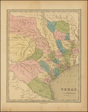
Landmark Map of the West Made by a French Spy in the Tumultuous 1840s
Fine example of Duflot De Mofras' richly-detailed and large map of the Western United States, Canada, and Texas—one of the scarcest and most important maps of the region published in the nineteenth century. A particular highlight is the Russian colony in California—this is the first time the name Fort Ross was included on a widely-available map.
Duflot de Mofras traveled extensively in the Spanish possessions of the American Southwest, gathering information and meetings with officials from the United States, European powers, and trading companies. All the while, he was gathering intelligence for the French, who were interested in setting up outposts in the West. This map is the fascinating distillation of what he learned.
Extending from Mount St. Elias in Alaska and Hudson’s Bay to Acapulco in Mexico, the map stretches from Austin, Texas in the east to the Oregon Country and California in the west. It is a masterpiece of contemporary observations and assiduous compilation. Wheat refers to the map as, “[a] landmark . . . because it made these western regions known in European official circles.”
The first feature to jump out at the viewer is the dark line of mountains, the Rockies, which form the backbone of this area. The Sierra Nevada Mountains are also emphasized. Rivers form a web over the landscape, with the Missouri and Columbia Rivers especially evident.
A key near the title explains all the man-made features included on the map: principal settlements, villages or pueblos; farms, stations, or ranches; missions, fort or garrisons, native settlements and camps, mines, and ports or moorings. These are followed by explanations of the tracks that line the map. These include itineraries of routes and explorers, agreed borders, proposed borders, and the possessions of the British, United States, Russians, Mexicans, and Texans, and the Oregon Country, which is described as under litigation.
While the political boundaries—those that were agreed and those that were still in flux—are a major part of this map, it is important to stress the ubiquitous indigenous presence in every area shown here. De Mofras has included the names of American Indian tribes in addition to European settlements or claims.
Texas, which declared independence from Mexico in 1836, is shown here with several land grants marked. Its northern border was adopted from the 1819 Adams-Onís Treaty between the United States and Spain. A sliver of Missouri and part of Iowa Territory is included, which gives way to the lands controlled by the Hudson’s Bay Company (HBC). British Canada and the HBC lands are separated from the United States by the 49th parallel, a border agreed for the eastern part of the map and one that was still under dispute in the west after discussions in 1818. Both this and the line proposed by the US in 1826 are marked here.
Russian Alaska hugs the shoreline in the northwest; it is neighbored by British Canada to the east. Between the 54th and 55th parallels north is another border, this one agreed between the Russians and the United States to limit Russian expansion along the Pacific Northwest coast in 1824. A Russian colony is also nestled into California. This was established in 1812 and sold to John Sutter, of Gold Rush fame, in 1841. This is the first time it was shown in such detail on a publicly-available map.
Individual expeditions are noted. For example, in the north of the Oregon Country is a short route that references McKenzie in 1793. This alludes to a portion of the overland exploration led by Alexander McKenzie. He accomplished the first east-to-west crossing of North America north of Mexico in 1792-3, starting at the Peace River and making it all the way to the Pacific.
Duflot de Mofras was especially interested in travel routes. One leads from the east to Santa Fe, which he noted as the “Route des Charriots des Etats-Unis.” This is the Santa Fe Trail, which connected Franklin, Missouri to Santa Fe, where another set of trails could take goods and travelers farther west; this latter route became known as the Old Spanish Trail. The Santa Fe route was first broken by William Becknell in 1821. This is one of the first times it appeared on a printed map, although de Mofras places it too far south. Another important route is the Oregon Trail--which in is latter part follows the track of Lewis and Clark, which is also inlcuded--still new when this map was made, but which saw more and more pioneers traversing its paths to Oregon and California each year of the 1840s.
Wheat states that this beautifully-engraved map was often used by European cartographers as the basis for early Gold Rush-era maps of California and the neighboring territories. Rumsey adds that the map leans on the rare 1837 edition of John Arrowsmith's map of British North America. While not a copy of the Arrowsmith, it clearly followed the Arrowsmith map in many respects.
The map is truly a landmark. Because of the nature and importance of De Mofras' work, the map is rare on the market, this being one of only a few examples offered on the market in the past 25 years.
The travels of Eugene Duflot de Mofras in the American West
In 1839, Eugene Duflot de Mofras (1810-1884), was assigned to the French embassy in Mexico City and instructed to visit the northwestern provinces of Mexico, report on potential commerce, observe US, British, and Russian interests, and determine the feasibility of French trading posts in the region. In effect, he was acting as a spy, undertaking reconnaissance of the West and assessing the relative strengths and interests of the United States, Britain, Mexico, and Russia.
De Mofras visited Jalisco, Colima, Sinaloa, and Sonora in 1840, then sailed from Mazatlán to Monterey. He met with commandant Mariano Guadalupe Vallejo in Sonoma, continued to Fort Ross, and returned to Monterey in July. He then sailed up the Sacramento River with A.G. Rotchev, Governor of the Russian colony and manager of Fort Ross, to New Helvetia, where he met with John Sutter, with whom Rotchev was negotiating for the sale of the Russian fort.
He later visited San Jose, Santa Cruz, and San Francisco, before traveling to the HBC’s Fort Vancouver. On this trip, de Mofras met and talked with Charles Wilkes, the commander of the United States Exploring Expedition. He returned to San Francisco with HBC Director Sir George Simpson, factor John McLoughlin, and US agent Horatio Hale. On January 3, 1842, de Mofras sailed via Santa Bárbara to San Diego, before returning to Mexico.
Duflot de Mofras provided important information on the economic life, geopolitics, and geography of the American West. He gave excellent descriptions of the Russian posts at Fort Ross and Bodega just prior to their sale and of California in general prior to the Gold Rush. He specifically noted Sutter's willingness to serve France, and reported on the reputed plot of Isaac Graham to overthrow the Mexican government in California.
The map was issued in 1844 in two and perhaps three different formats (standard paper, large paper, and grand paper). The grand paper edition was advertised by the publisher in the Gazette Nationale as being available for purchase; however, at least one bibliographer commented that it was not known if any of the grand paper maps were actually produced. The map appeared both separately, as with this example, and as part of the atlas volume of de Mofras’ Exploration Du territoire de l’Orégon, des Californies et de la mer Vermeille.
This was one of the first maps of this region available to a European audience in such detail. While the French never managed to join the imperial race in the area, European prospectors would use the map during the Gold Rush, and mapmakers patterned their own maps off of de Mofras’ exceedingly-detailed work.
Western North America in the 1840s
Since the publication of James Cook’s third voyage account, and compounded by the Louisiana Purchase and the reports of the Lewis & Clark expedition, the American West had been a region of interest and speculation for many Europeans and Americans in the early nineteenth century. It supposedly held rich farmlands ripe for European settlement and lucrative natural resources, including gold. In the early nineteenth century, the only Europeans in the area were those who came by ship, like Cook, or those who travelled overland from the areas that are now California (Spaniards and Mexicans) and Canada (British).
Also present, as this map shows, were Russian traders and settlers. The first Russians to encounter Alaska were members of Vitus Bering’s Second Kamchatka Expedition (1733-43). In 1784, Grigory Shelikhov established the first permanent settlement at Three Saints Bay on Kodiak Island. In 1799, Shelikhov’s successor, Alexsandr Baranov, set up the Russian American Company, which held a monopoly over trading in Alaska.
The Company’s employees and settlers set up several settlements in Alaska. By the early 1800s, thanks to passage on American trips and partnerships with American trappers and traders, the Russians began to visit the California coast. They made possession claims in 1809 and founded a colony in 1812 near Bodega Bay, with Fort Ross as their headquarters.
The colony provided agricultural goods to the trading posts in Alaska. By 1838, however, the Russian American Company reached an agreement to have HBC forts supply their agricultural needs and decided to sell the California colony. They offered Fort Ross to several prominent settlers and the successful buyer was John Sutter, a Swiss immigrant and newly-minted citizen of Mexico.
Like the Russian American Company, many came to take advantage of the lucrative fur trade in the late eighteenth century. The aforementioned HBC is the most famous of the several companies who attempted to monopolize the fur business. In 1818, Britain and the United States, eager to shut out competition and to lock down the promise of the region, agreed by treaty to share sovereignty over the Pacific Northwest.
Over time, however, this alliance frayed in light of continued growth by the HBC and pressure from United States settlers eager to gain recognition from the US government. The boundary was renegotiated in 1826; the 49th parallel was discussed but no resolution was reached, as referenced on this map.
In 1812, Robert Stuart discovered a route over the Continental Divide, South Pass, which was safe for wagons to cross. Stuart, who worked for the Pacific Fur Company, had started at the Columbia River and journeyed east and over South Pass into what is now Wyoming; he proved it possible to get over both the Blue and the Rocky Mountains via wagon.
In the 1830s, settlers began to follow the route west, inspired by books like Hall Jackson Kelly’s A Geographical Sketch of that Part of North America called Oregon (1830) and his General Circular to All Persons of Good Character Who Wish to Emigrate to the Oregon Territory (1831). The first wagon train, organized by Nathaniel Wyeth and guided by William Sublette, a fur trader, made the crossing in 1831. Three farmers from that group became the first Americans to settle in what is now Oregon, joining British subjects, mostly HBC employees, already farming in the Willamette Valley. Wyeth organized another wagon train in 1834; it did not succeed in shifting a large number of people to Oregon, but one of its members, the missionary Jason Lee, did stay and started to attract others to join him.
Inspired by Lee and other missionaries like Marcus Whitman, the United States government took up the subject of Oregon’s status. In 1838, Senator Lewis Linn of Missouri proposed a bill that would authorize settlement. Linn proposed several similar bills between 1838 and 1843, his voice forming the core of a rising clamor to integrate Oregon into the United States. A county in Oregon would eventually be named for him.
The House Committee on Foreign Affairs also took up the topic of the Oregon Country. Caleb Cushing, a Representative from Massachusetts, began arguing for the US’s claim to Oregon by right of first discovery. In January 1839, he led the Foreign Affairs Committee to issue a report that favored the creation of a military presence in Oregon, in order to defend the US’s claim to the land and its use. Included in the report were letters from those already living in Oregon who were desperate for a governor and magistrate; they wanted reassurance that their new farms were legal claims. The reports were convincing; the House ordered 10,000 extra copies to be printed and distributed to the American people.
The reports must have been effective, along with a flurry of guidebooks and maps. The 1840s was the boom decade of the Oregon Trail, the route of which is marked on this map. Between 1840 and 1860, 400,000 journeyed overland on the 2,000 mile Oregon Trail; they formed one of the largest mass migrations in American history. By the late 1830s, the American settlers began to outnumber the British in Oregon Country.
In the US Presidential Election of 1844, ongoing as this map was published, James K. Polk ran on a platform that used the slogan “54°40 or Fight!” This referred to the boundary line to be established between British Canada and the United States. This parallel was just below the boundary of Russian settlement in Alaska, seen here, and effectively shut the British out of much of the Pacific Northwest coastline.
Polk was elected but quickly became embroiled in another border dispute to the south, the Mexican-American War (1846-8). Rather than fighting on two fronts, Polk tried to negotiate the northern border with the British. By this time, Americans outnumbered the British in Oregon six to one. The British, eager to protect the forts they had built via the HBC, wanted a parallel at the 42nd parallel. Polk compromised on the 49th, precisely the parallel shown on this map. The border treaty was signed in June 1846.
This left Polk free to focus on the conflict in Texas, which had declared and won its independence from Mexico in 1836. In 1845, Texas joined the United States as the 28th state, leading to heightened tensions with Mexico. Polk offered to buy much of the American Southwest, but Mexico quickly refused. Instead, Polk moved American troops into a disputed zone between the Rio Grande and the Nueces River. On April 25, 1846, Mexican troops attacked the Americans, igniting open war. The American troops pushed south, into Mexico. The Mexican Army was led by the famous General Santa Anna, but they could not defeat the advancing US Army. The fighting was calmed in September 1847, when General Winfield Scott reached Mexico City.
The war was officially ended with the Treaty of Guadalupe-Hidalgo on February 2, 1848. This established the Rio Grande as the border between Texas and Mexico, rather than the Nueces River. The United States also gained control of the American Southwest, from Texas west to California—525,000 square miles, an entire third of the territory of Mexico. In return, the US government paid Mexico fifteen million dollars and agreed to pay damages to Americans seeking claims against Mexico.
The gem of this deal was California. Americans had already been living in Alta California, as it was known, particularly around San Francisco, which had a port. Most of the roughly 7,300 settlers (of all backgrounds) were involved in the fur trade or agriculture. Only nine days before the Treaty of Guadalupe Hidalgo was signed, however, gold was discovered at Sutter’s Mill—the same John Sutter who had purchased Fort Ross. This set off the great California Gold Rush, with ‘49ers abandoning vessels in San Francisco Bay to dig for the precious medal.
Territories required a population of 60,000 before they could apply for statehood. California surmounted that number of new settlers in 1849 alone. Legislators allowed California to skip territory status and enter the Union as the 31st state, but only after a rancorous fight over whether it would be a free or a slave state. It was declared a free state, part of the Compromise of 1850.
Oregon Country, by contrast, was initially left unincorporated. However, on November 29, 1847, Marcus Whitman, his wife Narcissa, and their children were killed by Cayuse people during an attack on the mission. The Cayuse accused Whitman of poisoning Cayuse who had been in his care. Whitman had guided one of the first large wagon trains west and was well known to lawmakers in Washington D.C. Outraged by the violence, but not, apparently, by the alleged poisonings of the Cayuse, Congress began to organize to have Oregon brought under direct US control. Oregon was officially incorporated as a US Territory on August 14, 1848.
This map was made during this momentous time in American history. It records important historical moments, especially the Russian colony at Bodega Bay. Rare on the market, the map is an important milestone in the cartography of western North America and the American West.
Eugene Duflot de Mofras was a traveler, naturalist, diplomat, and spy. In 1839, du Mofras was appointed attaché to the French delegation to the Mexican government. While there, he was tasked with visiting the northern areas of Mexico; he was sent both as an official visitor but also as a veritable spy, gathering intelligence as to likely places to establish French trading posts. In 1844 he published an account of his travels, complete with an influential map of western North America.

![[Coastal Orange County] Santa Ana Quadrangle](https://storage.googleapis.com/raremaps/img/small/83561.jpg)

![Mexico [with Southwestern U.S., Texas, etc.]](https://storage.googleapis.com/raremaps/img/small/97606.jpg)