|
||

|

|
|

|
Overview of South Polar Exploration and Conjecture in the First Half of the Eighteenth Century
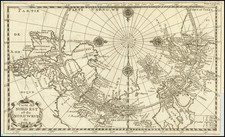
Remarkable map of the southern hemisphere, most notable for its depiction of Buache's conjectural Antarctic lands and interior sea. It also depicts New Zealand as a part of the Terres Antarctiques.
This map was Buache's second attempt at depicting the southern hemisphere. The first edition of this map lacked any attempt to map Antarctica. Instead, it consolidated the findings and routes of known voyages to that point and showed the vast space that Buache thought must be filled with a large continent.
Buache's map is discussed in depth by Geography Geek here.
In this second edition of the map, Buache has sketched a conjectural depiction of what is now called Antarctica. The landmass is split into two with a large Mer Glaciale running through their middle. The smaller of the two is separated from Tierra del Fuego but extends north to land supposedly seen by Amerigo Vespucci in 1503 and that spotted by Bouvet de Lozier in 1739.
Across the frozen sea is the larger of the two of Buache’s Antarctic lands. This one includes the Terre des Perroquets, supposedly contacted by Portuguese sailors, and Terre de Gonneville, an apocryphal coast created by the Abbe de Paulmier in the second half of the seventeenth century. It extends east, running well south of Van Diemen’s Land, which had been skirted by Tasman in his voyage of 1642-3. Farther east in the Pacific the shore twists north to include New Zealand, which was also contacted by Tasman.
As with the earlier version of this map, outside the hemispheric projection is an account of the 1738-9 expedition of Bouvet de Lozier, which mentions the discovery of icebergs between two and three hundred feet high and half a league to two or three leagues in circumference. Bouvet’s sighting of Cap de la Circoncision is near one of the entrances to the polar sea. The other opening into the inland sea, to the southwest of South America, was placed where the buccaneers Sharpe and Davis had reported icebergs in 1687. Buache believed that the icebergs must have derived from a floating ice sheet, as in the Arctic, which is explained in the note on the larger of the two Antarctic islands. This hypothesis led him to conclude that the southern continent was not a single landmass but two islands separated by a frozen inland sea, from which icebergs detached themselves to float northwards.
The inland sea theory was based upon work Buache had developed over a number of years. His ideas were presented to the Académie des Sciences in 1744, published as Considérations géographiques sur les terres australes et antarctiques in 1761, and republished in English in The Gentleman's Magazine in 1763. In it, he hypothesized that the southern pole must contain a frozen sea, fed by mountain ranges and huge rivers in order to produce icebergs of the size reported by Bouvet, Halley, and others.
States of the map
The privilege in the lower right corner is the same as on the first edition of this map. Buache modified the 1739 state with his hypothetical southern continent and presented it to the Académie des Sciences in 1754. This second state was supposedly published in 1754, which is the date printed on the map and the date most libraries and scholars attribute to the map. However, there is a track on all surviving examples of the Spanish ship “le Lion en 1756.”
Both Georg Forster and Charles Burney include this voyage in their accounts of Pacific exploration. The Leon supposedly spotted land in 54°S in June 1756 on a return voyage from Callao, Peru around Cape Horn. This sighting was later confirmed by James Cook, who named the archipelago the South Sandwich Islands. Therefore, the likely date of this second state is at least 1756; perhaps initially meant for a 1754 publication, the state was delayed in reaching the press, allowing for additional changes. The map appeared in Dezauche’s Cartes et tables de la géographie physique ou naturelle (1757), so the second state is more properly dated 1757.
The 1770 edition of this atlas included plate numbers. The present example carries a plate number of xiv in the top right corner and has a different address—Rue des Noyers as opposed to Quay de l’Horlage. The former address is the shop of Jean-Claude Dezauche. Thus, this state is dated to ca. 1770.
Watch Geography Geek's Video on Terra Australis:
Philippe Buache (1700-1773) was one of the most famous French geographers of the eighteenth century. Buache was married to the daughter of the eminent Guillaume Delisle and worked with his father-in-law, carrying on the business after Guillaume died. Buache gained the title geographe du roi in 1729 and was elected to the Academie des Sciences in the same year. Buache was a pioneering theoretical geographer, especially as regards contour lines and watersheds. He is best known for his works such as Considérations géographiques et physiques sur les découvertes nouvelles dans la grande mer (Paris, 1754).
![[Alaska, Northwest Coast and North Pacific Ocean] Der Noerdliche Theil des Grossenwelt Meeres . . . 1804](https://storage.googleapis.com/raremaps/img/small/80463.jpg)
![Navigatio ac Itinerarium Iohannis Hugonis Linscotani in Orientalem Sive Lusitanorum Indiam... [Voyage and Journey of Jan Huygen van Linschoten to the Eastern, or Portuguese India...]](https://storage.googleapis.com/raremaps/img/small/93009.jpg)
![[Magellan's Strait] Exquisita & magno aliquot mensium periculo Lustrata et iam retecta Freti Magellanici Facies . . .](https://storage.googleapis.com/raremaps/img/small/94451.jpg)