|
||

|

|
|

|
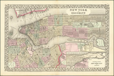
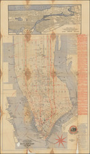
Nice example of the map showing General Grant's Position during the Battle of Long Island in 1776.
The map shows the movements of Admiral William Howe, the Camp of Generals Sullivan and Stirling, Grant's route to Brooklyn Ferry and De Haister's Hessians, along with the British Camp. From Stedman's History of the American War.
Grant & Battle of Long Island
As the British tried to gain control of New York City, General James Grant, Laird of Ballindalloch, had become Lord Admiral Howe's primary planning officer. He developed two plans, each designed to both gain control of territory and to deal a serious or fatal blow to the Continental Army. These resulted in the Battle of Brooklyn, and Battle of White Plains.
In the Battle of Long Island on August 26-27, 1776, General Grant led the division that landed on the left wing. He was to engage the American right and divert attention from Howe's flanking maneuver with the main body. An advance unit of his troops engaged the Americans at the Red Lion Inn, which was the first engagement of the battle. Grant completed his mission, and strongly defeated the American General William Alexander's division.
After the event, Grant was criticized by some for allowing the escape of most of this force. He had almost 7,000 men in ten regiments opposing Alexander's 1,600 Continentals, but there were factors at play other than troop strength. First, Grant stopped his advance according to the British plan, awaiting Howe's attack on the American rear, rather than attacking the Americans who were dug in on the Brooklyn heights. Second, he was running low on ammunition. Boats and logistic support were busy ferrying and supplying the Hessian units on the right and the main body that was landing at Gravesend, Brooklyn.
William Faden (1749-1836) was the most prominent London mapmaker and publisher of the late-eighteenth and early-nineteenth centuries. His father, William Mackfaden, was a printer who dropped the first part of his last name due to the Jacobite rising of 1745.
Apprenticed to an engraver in the Clothworkers' Company, he was made free of the Company in August of 1771. He entered into a partnership with the family of Thomas Jeffreys, a prolific and well-respected mapmaker who had recently died in 1771. This partnership lasted until 1776.
Also in 1776, Faden joined the Society of Civil Engineers, which later changed its name to the Smeatonian Society of Civil Engineers. The Smeatonians operated as an elite, yet practical, dining club and his membership led Faden to several engineering publications, including canal plans and plans of other new engineering projects.
Faden's star rose during the American Revolution, when he produced popular maps and atlases focused on the American colonies and the battles that raged within them. In 1783, just as the war ended, Faden inherited his father's estate, allowing him to fully control his business and expand it; in the same year he gained the title "Geographer in Ordinary to his Majesty."
Faden also commanded a large stock of British county maps, which made him attractive as a partner to the Ordnance Survey; he published the first Ordnance map in 1801, a map of Kent. The Admiralty also admired his work and acquired some of his plates which were re-issued as official naval charts.
Faden was renowned for his ingenuity as well as his business acumen. In 1796 he was awarded a gold medal by the Society of Arts. With his brother-in-law, the astronomer and painter John Russell, he created the first extant lunar globe.
After retiring in 1823 the lucrative business passed to James Wyld, a former apprentice. He died in Shepperton in 1826, leaving a large estate.