
This item has been sold, but you can enter your email address to be notified if another example becomes available.


|
||

|

|
|

|
Stock# 71469
Description
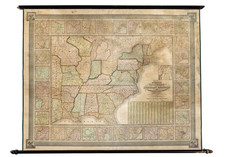
Fine example of this impressive large format map of North America.
Monk's map highlights the evolution of the territories west of the Mississippi River.
- Washington and Oregon Territory extend to the Rocky Mountains.
- A massive Nebraska Territory extends north to Canada and west to the Rocky Mountains.
- Utah Territory and New Mexico Territory extend from California to Texas and Kansas.
- A region called "Gadsden" is shown south of New Mexico.
- Massive Kansas Territory, running from Iowa to the Rocky Mountains, illustrating the region in the year before the discovery of Gold in what would become Kansas Territory in 1859.
The map illustrates a number of the massive western Territorial counties. Many Indian Tribal lands are illustrated, as are early forts, explorations routes and early proposed routes for the Transcontinental Railroad. Western exploration routes and early roads include:
- The overland mail route to California.
- Santa Fe Expedition, 1841.
- Route from Ft. Smith to Santa Fe (820 miles).
- Oregon Trail (Council Bluffs to California)
- Proposed rail route from St. Paul to Vancouver.
- Proposed rail road from Westport to San Francisco (2080 miles).
- Emory's route to California.
Only a few Counties shown in Southern California, including San Diego, San Bernardino, Los Angelos (sic) and Santa Barbara.
This is the third of Monk's major wall maps of North America.
- New Map of that Portion of North America . . . (1850-1854)
- Monk's New American Map Exhibiting the Larger Portion of North America (1855-1857)
- Monk's Standard American Map Exhibiting the Large Portion of North America (1858-
The condition of this example is quite exceptional, lacking the usual staining and chipping.
![[German Northern Pacific Promotional Tract] Die Nordliche Pacific Eisenbahn; Ihre Route, hulfsquellen, fortschritte & Gefchafte. der neue Nord-Westen und seine grosse Verkehrs-Strasse.](https://storage.googleapis.com/raremaps/img/small/83777.jpg)
![[ British Colonies in North America ] Carte Nouvelle de L'Amerique Angloise contenant tout ce que les Anglois possedent sur le Continent de L'Amerique Septentrionale . . .](https://storage.googleapis.com/raremaps/img/small/100143.jpg)