
The item illustrated and described below is sold, but we
have another example in stock. To view the example which
is currently being offered for sale, click the
"View Details" button below.


|
||

|

|
|

|
Stock# 71429
Description
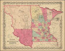
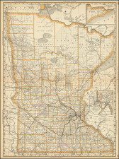
Important early atlas map of Minnesota Territory, immediately after the creation of Dakota Territory.
The northern counties of Minnesota are still very primitive, with only Red Lake, St. Louis, Itasca, Pembina and Cass named. The north is dominated by Chippewa Country. Many early towns are named, along with lakes, rivers, Indian villages, forts, roads, rivers, early railroads and proposed railroad routes, etc.
Several annotations on the explorations of the Upper Red River, etc.
Dating the map:
- Decorative border (therefore not the 1857 edition)
- Polk County not yet shown (created July 19, 1858)
- Wadena County not yet shown (created June 10, 1858)
![[ Northern Pacific Railroad ] NEW 7-30 GOLD LOAN OF THE Northern Pacific Railroad Co. SECURED BY FIRST MORTGAGE ON RAILROAD AND LAND GRANT. SAFE! PROFITABLE! PERMANENT!](https://storage.googleapis.com/raremaps/img/small/101828.jpg)
![[First Map of the Mississippi River] Carte de la decouverte faite l'an dans l'Amerique Septentrionale](https://storage.googleapis.com/raremaps/img/small/93571.jpg)