


|
||

|

|
|

|
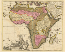
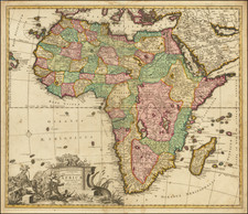
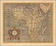
Fine Large-Format Map of Africa by Jaillot
Striking map of the continent of Africa, by the French mapmaker Alexis-Hubert Jaillot. Although the imprint line has not been updated, this example was probably published by Mortier in Amsterdam around 1696.
The map is an enlarged, updated state of a 1650 map by Nicholas Sanson, who is generally considered the father of French cartography.
The map shows the entirety of the continent, including Madagascar and parts of southern Europe, the Arabian Peninsula, and Brazil. In the Atlantic Ocean are the Azores, Canaries, and Cape Verde Islands, as well as several islands in the southern Atlantic. Also included is St. Helena and a “S. Helena Nova,” an island created by Guillaume Sanson in his version of the map printed in 1669.
The continent is split into political units, which are listed in the title located outside the top plate edge. It also contains physical features like lakes and mountains. Interestingly, the famous Mountains of the Moon, the supposed source of the Nile River since ancient times, are not included here. Neither were they on the original version of this map, published by Nicholas Sanson in 1650. Jaillot has also altered the river system south of the two great central lakes, where Sanson had placed the Zambezi too far south.
In the upper left corner is a cartouche holding six scale bars. It also identifies Jaillot and the date of the map, as does the title cartouche in the upper right corner. This ornate cartouche is decorated with Greek-style male gods, two black men, a lion, ostrich, elephant, and alligator.
The cartouche includes a dedication to the Dauphin, who in 1692, when this map was made, was Louis, son of Louis XIV. This Louis (1661-1711) was the Sun King’s oldest son. However, the Grand Dauphin predeceased his father, as did Louis’ son, also Louis, known as the Petit Dauphin (d. 1712). The throne, therefore, passed to the Sun King’s great-grandson, yet another Louis, who was only five years old in 1715, when the crown passed to him.
As mentioned above, this map originated in 1650 and was completed by Nicholas Sanson for his Cartes générales de toutes les parties du monde, the first French world atlas. This first state of the map also rejected the Mountains of the Moon, as did Ortelius before him. Indeed, this map draws upon Ortelius’s sixteenth-century map of Africa, except that Ortelius’ two-lake structure in Central Africa connected to both the Congo River and the Limpopo. Other sources for Sanson included Gastaldi’s rendition of Africa and Blaeu’s 1608 map of the continent. Guillaume Sanson released a slightly-altered state of the map in 1669, which shows slightly less of Brazil, to the west, and added the chimerical extra St. Helena.
This state is larger than the Sanson states, and therefore again shifts the western border of the map, this time to include more of Brazil than either of the Sanson states. Jaillot was in partnership with Nicholas Sanson’s sons and he re-published many of the elder Sanson’s map. The enlarged map of Africa first appeared in 1674 and was re-printed due to its exacting detail and aesthetic appeal.
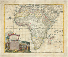
Not enough can be said about the original hand-coloring of this example, which is especially careful, fresh, and strong.
Alexis-Hubert Jaillot (ca. 1632-1712) was one of the most important French cartographers of the seventeenth century. Jaillot traveled to Paris with his brother, Simon, in 1657, hoping to take advantage of Louis XIV's call to the artists and scientists of France to settle and work in Paris. Originally a sculptor, he married the daughter of Nicholas Berey, Jeanne Berey, in 1664, and went into partnership with Nicholas Sanson's sons. Beginning in 1669, he re-engraved and often enlarged many of Sanson's maps, filling in the gap left by the destruction of the Blaeu's printing establishment in 1672.
![[ World & Continents ] Typus Orbis Terrarum / Americae Sive Novi Orbis Nova Descriptio / Asiae Nova Descriptio / Africae Tabula Nova / Europae](https://storage.googleapis.com/raremaps/img/small/99250.jpg)