
The item illustrated and described below is sold, but we
have another example in stock. To view the example which
is currently being offered for sale, click the
"View Details" button below.


|
||

|

|
|

|
Stock# 71145
Description
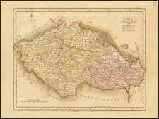
A fabulous regional map of Bohemia, Moravia, Silesia, Eger and Glatz, showing many long lost provincial borders, including Pilsen, Saatz, Leutmeritz, Buntzlau, Konigsgratz, Glatz, Olmutz, Chrudim, Cazslau, Kaurzim, Beraun, Rakonitz, Prachin, Bechin, Eger, and small area on the Bavarian border called Royal Free Peasants.
Shows towns, rivers, mountains, etc. Large table of Bohemian states.
Striking engraving and original wash colors. Robert Wilkinson was active in London as a cartographic publisher from 1785 to 1825. He produced a number of nice works, including a General Atlas and a re-issuance of Bowen & Kitchen's English Atlas, along with excellent large format separate maps.
![[Prague] Panorama Kralovske Prahy](https://storage.googleapis.com/raremaps/img/small/89611.jpg)
![[ Holy Roman Empire ] Germania, Non ea tantum quae Rheno, Vistula, Danubio, mariqz Germanico Veteribus claudebatur; Sed tota illa continens quae hodie communiter Germanica lingua utitur . . .](https://storage.googleapis.com/raremaps/img/small/99236.jpg)
![(Second World War - Holocaust) Walki z najezdzca Hitlerowskim I zbrodnie Hitlerowskie na terenie wojewodztw: Bialostockiego, Lomzynskiego i Suwalskiego w latach 1939-1945 [Fights with the Nazi invaders and Nazi crimes in the following voivodeships: Bialostocki, Lomzynskie and Suwałki in 1939-1945]](https://storage.googleapis.com/raremaps/img/small/82911.jpg)