


|
||

|

|
|

|
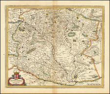
First State, from 1683, the Year of the Siege of Vienna.
Rare, large engraved map of southeastern Europe, published by William Berry in London in 1683.
The map was published at a pivotal point in the history of the region; in 1683, the Ottoman Empire was at its apex in southeastern Europe, as the title suggests - it occupied all of the territories up to Vienna, the stronghold of the Holy Roman Empire. The Siege of Vienna lasted for two months and marked the turning point in the 300-year Ottoman-Habsburg struggle; after the Siege was lifted, with the Holy Roman Empire victorious, they slowly recovered Hungary and Transylvania. The Holy Roman Empire would retake Budapest just three years after the map was published.
Vienna can be seen in the upper-left corner.
First state, with the imprint of William Berry: "Sold by William Berry, at the Sign of the Globe, between Charing-Cross and White-Hall."
![[Danube River Survey] Alap's Vizhelyezeti Térképe Buda és Pest szabad király fő városainak, mellyet á N.M.M.K. Helytartó Tanács kegyes Engedelme mellett á magyar országi Tekintetes Epito fő Kormány . . . Tagjainak alarzatos tisztelettel ajánl Vörös László á kiadó és országos dunamérési hiteles földmérő. Budan MDCCCXXXIII.](https://storage.googleapis.com/raremaps/img/small/57469.jpg)
![[ Postal Map of Eastern Europe ] Deutschlands Postkarte begraenzt von Oesterrreich, Preussen, Frankreich, Holland, Italien und der Schweiz. Gezeichnet und Herausgegeben von Ignaz Heymann. K.K. Obserpostamtsoffizier in Trieste. 1800.](https://storage.googleapis.com/raremaps/img/small/77678.jpg)
![[Croatia & Slovenia] Illyricum](https://storage.googleapis.com/raremaps/img/small/91649.jpg)