


|
||

|

|
|

|
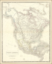
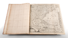
A Fascinating Pre-Louisiana Purchase Map of North America
Scarce early map of North America, shortly before the Louisiana Purchase.
An interesting time period, immediately preceding the reports of Alexander von Humboldt and Zebulon Pike, in the year prior to the Louisiana Purchase.
The map includes the important information first added by Arrowsmith to his larger maps and utilized by Lewis & Clark . For Lewis & Clark, the most notable information was the tentative tributaries for the Upper Missouri River regions. The 1802 Arrowsmith was the first to show the Upper Missouri joined with the Mississippi River in its correct location.
Above and west of the Mandan Villages, the map incorporates for the first time the reports of Peter Fidler for the Hudson's Bay Company, by including a series of possible river courses to the west, leading to (and prospectively through) the Rocky Mountains. It was this section of the map that provided the best depiction of the prospect of a water route or portage through the Rocky Mountains and to the Pacific. It was this information, along with reports from local Indians encountered on the expedition, which Lewis & Clark relied in choosing their path to the Rocky Mountains.
The large blank areas in the west show how little was known about the lands up the Missouri River Valley and across the Rocky Mountains and reflect the blank canvas upon which the mapping of the west would be drawn over the next 4 decades. Explorers had probed the edges of the region, but Europeans had not yet penetrated the interior.
The Arrowsmiths were a cartographic dynasty which operated from the late-eighteenth century to the mid-nineteenth. The family business was founded by Aaron Arrowsmith (1750-1823), who was renowned for carefully prepared and meticulously updated maps, globes, and charts. He created many maps that covered multiple sheets and which were massive in total size. His spare yet exacting style was recognized around the world and mapmakers from other countries, especially the young country of the United States, sought his maps and charts as exemplars for their own work.
Aaron Arrowsmith was born in County Durham in 1750. He came to London for work around 1770, where he found employment as a surveyor for the city’s mapmakers. By 1790, he had set up his own shop which specialized in general charts. Arrowsmith had five premises in his career, most of which were located on or near Soho Square, a neighborhood the led him to rub shoulders with the likes of Joseph Banks, the naturalist, and Matthew Flinders, the hydrographer.
Through his business ties and employment at the Hydrographic Office, Arrowsmith made other important relationships with Alexander Dalrymple, the Hudson’s Bay Company, and others entities. In 1810 he became Hydrographer to the Prince of Wales and, in 1820, Hydrographer to the King.
Aaron Arrowsmith died in 1823, whereby the business and title of Hydrographer to the King passed to his sons, Aaron and Samuel, and, later, his nephew, John. Aaron Jr. (1802-1854) was a founder member of the Royal Geographical Society (RGS) and left the family business in 1832; instead, he enrolled at Oxford to study to become a minister. Samuel (1805-1839) joined Aaron as a partner in the business and they traded together until Aaron left for the ministry. Samuel died at age 34 in 1839; his brother presided over his funeral. The remaining stock and copper plates were bought at auction by John Arrowsmith, their cousin.
John (1790-1873) operated his own independent business after his uncle, Aaron Arrowsmith Sr., died. After 1839, John moved into the Soho premises of his uncle and cousins. John enjoyed considerable recognition in the geography and exploration community. Like Aaron Jr., John was a founder member of the RGS and would serve as its unofficial cartographer for 43 years. Several geographical features in Australia and Canada are named after him. He carried the title Hydrographer to Queen Victoria. He died in 1873 and the majority of his stock was eventually bought by Edward Stanford, who co-founded Stanford’s map shop, which is still open in Covent Garden, London today.
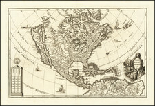
![A New Mapp of America Septentrionale . . . 1669 [California shown as an island]](https://storage.googleapis.com/raremaps/img/small/94304.jpg)
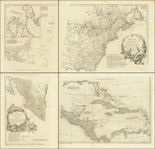
![[Revolutionary War Plans of New York, Boston, Charleston, Delaware River to Philadelphia & Havana] Various Plans and Draughts of Cities, Towns, Harbours &c . . .](https://storage.googleapis.com/raremaps/img/small/83450.jpg)