
This item has been sold, but you can enter your email address to be notified if another example becomes available.


|
||

|

|
|

|
Stock# 70426
Description
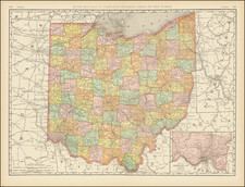
Highly detailed map of Ohio, published by OW Gray.
The map is colored by townships and showing towns, roads, railroads, Post Offices, etc.
Insets of Cleveland, Toledo, Columbus, Cincinnati and two smaller maps of the state.
Condition Description
Minor dampstaining in top margin.
O.W. Gray Biography
O. W. Gray was a publishing firm based in Philadelphia. Later, they published as O. W. Gray & Son. They published atlases in the late nineteenth century. Gray's National Atlas was one of the most successful commercial ventures of the 1870s and one of the last to employ hand coloring on maps.
![A Topographical Description of Such Parts of North America as are Contained in the (Annexed) Map of Middle British Colonies, &c. in North America [with map:] A Map of the Middle British Colonies in North America. First published by Mr. Lewis Evans ... in 1755; and since Corrected and Improved, as also extended with the addition of New England, and bordering parts of Canada; from actual surveys ... by T. Pownall](https://storage.googleapis.com/raremaps/img/small/100077.jpg)
![(Cincinnati Lettersheet Map) Map of Cincinnati and its environs From Survey by R. H. Rickey [includes a manuscript letter about Cincinnati by Joseph Dana, Jr.]](https://storage.googleapis.com/raremaps/img/small/94090.jpg)
![[ Toledo, Ohio ] Toledo and Lake Erie Park and Casino](https://storage.googleapis.com/raremaps/img/small/76621.jpg)