![America noviter delineata Auct. Judoco Hondio [Extremely rare 3 panel carte a figures state] By Jodocus Hondius / Jan Jansson](https://storage.googleapis.com/raremaps/img/small/66116.jpg)


|
||

|

|
|

|
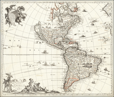
Extremely rare four-border 3rd state of Jansson's rare map of America, issued in 1623. The six views at the bottom are of South and Central American cities: Olinda, Cusco, Potosi, Ila Mocha, "R. Ianeiro", Mexico.
As noted by Philip Burden in the Supplement to his Mapping North of America to 1670, the Hondius-Jansson map of America is a fascinating and until recently, an under-appreciated rarity.
While at first blush the map appears similar to Blaeu's America, there are a number of differences. The Hondius-Jansson map includes inset views of North America, including the Poeiock Village in North Carolina, and views of Carolina and St. Augustine. The peninsular California is retained, with the extended Northwest Coast including definitive place names north of 40 degrees.
The East Coast of North America is rich with Indian names. The polar region inset is derived from Blaeu's wall map of 1608, as are the towns illustrated along the top.
The set of views at the bottom were removed very early in the printing history of the plate, probably so the map would more easily fit in the standard folio atlas of the day. Shortly after the plate was completed in 1623, the top right corner of the plate chipped off. After cataloging the map for the first volume of his work on North America, Burden learned of several new unrecorded states of the map, such that the history of the map is now believed to be as follows:
- State 1--1623: Henricus Hondius imprint only. No chip at top right corner (1 known example--University of Leiden)
- State 2--1623: Joannes Janssonius imprint added. No chip at top right corner (1 known example--British Library)
- State 3--1623 ca: Chip at top right corner
- State 4--1625: "excudit. 1625" added after Janssonius' name. Lower panels removed. (1 known example). German text on verso.
- State 5--1632: "excudit 1625" removed.
Burden surmises that this plate was made for Jansson and that the first several states of the map were proof states, all issued in short succession.
Jan Janssonius (also known as Johann or Jan Jansson or Janszoon) (1588-1664) was a renowned geographer and publisher of the seventeenth century, when the Dutch dominated map publishing in Europe. Born in Arnhem, Jan was first exposed to the trade via his father, who was also a bookseller and publisher. In 1612, Jan married the daughter of Jodocus Hondius, who was also a prominent mapmaker and seller. Jonssonius’ first maps date from 1616.
In the 1630s, Janssonius worked with his brother-in-law, Henricus Hondius. Their most successful venture was to reissue the Mercator-Hondius atlas. Jodocus Hondius had acquired the plates to the Mercator atlas, first published in 1595, and added 36 additional maps. After Hondius died in 1612, Henricus took over publication; Janssonius joined the venture in 1633. Eventually, the atlas was renamed the Atlas Novus and then the Atlas Major, by which time it had expanded to eleven volumes. Janssonius is also well known for his volume of English county maps, published in 1646.
Janssonius died in Amsterdam in 1664. His son-in-law, Johannes van Waesbergen, took over his business. Eventually, many of Janssonius’ plates were sold to Gerard Valck and Pieter Schenk, who added their names and continued to reissue the maps.
![[New General Map of North and South America Showing the Routes of Kruzenshtern and Lisyansky] НОВАЯ ГЕНЕРАЛЬНАЯ КАРТА СѢВЕРНОЙ И ЮЖНОЙ АМЕРИКИ СЪ ПОКАЗАНІЕМЪ ПУТЕЙ КРУЗЕНШТЕРНА И ЛИСЯНСКАГО](https://storage.googleapis.com/raremaps/img/small/58490.jpg)