|
||

|

|
|

|
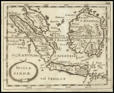
The Forbidden Map—the First Map of the Arrival of the Houtman Voyage in Southeast Asia
A superlative example of Willem Lodewijcksz's suppressed map of the region surrounding the Java Sea, the first detailed map of the area to appear in print.
This is an exceptional example of sixteenth-century Dutch cartography in striking and brilliant original hand-coloring.
The map stretches from the Nicobars in the northwest to Sumbawa in the southeast. It covers the Strait of Malacca, with two allusions to Singapore ("C. de Cinapura" and "Cinca"). All of Sumatra is shown, as is the Sunda Strait. The northern coast of Java is depicted, dense with the names of port cities. Southern Borneo also appears in the northeast of the map.
Intended as a general chart to situate readers in a voyage narrative, the map includes several decorative embellishments. The three compass roses and single half rose are oversized and embellished. In the lower right corner is an elaborate frame that includes a double scale bar.
In the lower-left corner is another cartouche in three parts. The center text box contains the title in Latin and Dutch with the initials of the mapmaker: G.M.A.L.— Guilelmus M.A. Lodewijcksz. The upper text box explains that the map was engraved by Joannes van Doetecum the Elder. In the lower frame is a watery menagerie of Indian Ocean sea creatures that were recorded by the Houtman expedition.
In the center of the map are four ships. These are the four ships of the Houtman fleet: Mauritius, Amsterdam, Hollandia, and Duifje.
In the top right corner is a set of six images. Those images relate some of what the Dutch saw in Java and Bali. They show vignettes of processions, meetings, local dress and ceremonies, and ships decked out for war and for transport. Full translations of the accompanying captions are available in MCN VII.
The suppression and publication of the map
Lodewijcksz was a participant in Cornelis de Houtman's voyage to Southeast Asia (1595-97), the first major Dutch voyage to the East Indies. The map was initially supposed to appear in Cornelis Claesz's publication of Lodewijcksz's logbook, which came out in April 1598. Though it contained illustrations of the Sunda Strait, Bali, and Java, as well as plans of the town and port of Banten, the journal did not include a general chart of the region.
Lodewijcksz provided this map to fill the gap. However, Claesz was forced to leave it out of the book. The Amsterdam shipowners and merchants who had outfitted the Houtman voyage wanted it kept sequestered to preserve the details of the nascent trade in spices upon which the Dutch were now embarking on a grand scale. This trade would become the purview of the famed Dutch East India Company, founded in 1602.
The map was so important because it was the jumping-off point for Dutch ambitions in Southeast Asia. Lodewijcksz himself wrote that if the Dutch were to secure a fort in Bantam (i.e. Batavia), they would have control of the navigation between the Moluccas and the Straits of Malacca and Sunda: "thus, the trade from here to the islands in the East would be safe-guarded, much to the advantage of our Netherlands."
The forbidden map was later published in 1598 as a separate map with Lodewijcksz’s initials. In the same year, De Bry utilized the map to illustrate his account of Linschoten's travels. The following year, De Bry also published Lodewijcksz's account as part III of the Petits Voyages.
Houtman’s voyage to the East Indies
Trade with the Indian subcontinent and the East Indies was becoming a central focus for the Dutch when this map was made. The Portuguese were the first Europeans to gain power in the East Indies, trading for spices in the Moluccas and controlling the spice market in Europe. The Dutch wanted in on the lucrative trade, but they also had to contend with the Portuguese.
The first step in establishing a trade was to gather information. Nine merchants sent Cornelis and Frederik de Houtman to Lisbon in 1592 to gather intelligence about the Portuguese spice trade. This had to be clandestine trip, as the united Crowns of Portugal and Spain closed the Iberian Peninsula’s ports to Dutch ships in 1585 as part of the Eighty Years’ War. The brothers were not careful enough, as they were imprisoned for attempting to steal charts of the East Indies sailing route. Two years later, the Houtmans did manage to return north and they carried details about the route to the East Indies and the Portuguese presence there.
Their return coincided with that of Jan Huygen van Linschoten from India. Together their reports convinced merchants that the Dutch should attempt to start a trade at Bantam. The merchants founded the Compagnie van Verre and financed a fleet of four ships to sail to the East Indies. The ships were under the command of Cornelis and the brothers and their crews left Amsterdam on April 2, 1595.
Unfortunately, this was not to be an easy voyage. Insufficient provisions meant that scurvy struck the crews only a few weeks after setting out. The brief stopover in Madagascar turned into a mass funeral for seventy sailors. Aboard ship numerous squabbles and disagreements broke out.
In June 1596, the ships arrived at Banten, a port in northwestern Java. They had passed through the Sunda Strait, not the Malacca Strait. The latter was under surveillance by the Portuguese and the Dutch ships did not want to risk a confrontation.
In Banten, Houtman met with the Sultan. The leader agreed upon a treaty with the Dutch. However, relations quickly soured due to Houtman’s lack of diplomacy. Instead, the ships tried to reach Madura but pirates attacked them en route. The ships limped into Madura and promptly attacked the people, who had received them peacefully, in retaliation for the acts of piracy. This proved rash; the pirates were not from Madura and the ships again had to sail on.
They next came ashore at Bali. Finally, they traded for a few peppercorns after meeting with the islands’ king. Later, at Bawean, the crews decided to burn the Amsterdam, one of the four ships, in order to consolidate their supplies and men. They turned back before ever reaching the actual Spice Islands, the Moluccas.
On their way home, the Portuguese prevented the ships from stopping at Saint Helena. 249 men had set out and only 87 returned. While the expedition was a disaster for most of the men involved, it provided an important victory for the Dutch. Houtman’s men did deliver some spices back to their merchant backers and they had made important initial contacts in Indonesia.
After Houtman, the second Dutch expedition (1598-1599) quickly set sail for the East Indies. It returned a 400% return for its investors. It quickly was followed by five others. In 1602, the most powerful of these merchants and the Dutch government, the States-General, created the Dutch East India Company (VOC), a monopoly to control the East Indies trade.
Cornelis died in battle against the forces of the Sultan of Aceh in 1599. Frederik was captured by the Sultan of Aceh when his brother was killed. While imprisoned, he studied the Malay language. Back in Amsterdam, he published the first Malay dictionary in 1603. He served as the governor of Amboina (Ambon) (1605-11) and the Moluccas (1621-23), an employee of the VOC. In 1619, he encountered shoals off the west coast of Australia which are named for him, the Houtman Abrolhos.
Rarity
As Schilder explains, compared to the similar maps of Plancius and van Linschoten, Lodewijcksz’s map is drawn to a higher resolution and includes far more detail on the western and northern coasts of Java. There are also more toponyms here than on contemporary maps.
Schilder locates twelve examples without text on the verso, like this example, although none are held in Southeast Asia. We are unable to trace a single copy in original color having ever appeared on the market.
![Plan der Stad en 't Kasteel Batavia Aanwyzing der Stad en Kasteels Punten [Map of the City and Castle Batavia Indication of the City and Castle Points.]](https://storage.googleapis.com/raremaps/img/small/93727.jpg)
![(Southeast Asia) [Unpublished Manuscript Sailing Directions from Europe to China by a French Navigational Officer]](https://storage.googleapis.com/raremaps/img/small/90507.jpg)