|
||

|

|
|

|
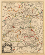
Attractive map of the country prior to the time of Napoleon. Colored by provinces. Shows rivers, towns, mountains, etc. One of the few maps on a spheriodical projection of this era. Attractive full wash color. Decorative cartouche and compass rose. Emanuel Bowen was one of the foremost cartographic publishers in England in the mid 18th Century.
Emanuel Bowen (1694?-1767) was a British engraver and print seller. He was most well-known for his atlases and county maps. Although he died in poverty, he was widely acknowledged for his expertise and was appointed as mapmaker to both George II of England and Louis XV of France. His business was carried on by his son, Thomas Bowen. He also trained many apprentices, two of whom became prominent mapmakers, Thomas Kitchin and Thomas Jeffreys.

![[ Holy Roman Empire ] Germania del Gastaldo](https://storage.googleapis.com/raremaps/img/small/73754.jpg)
![[ Paris in the time of the Romans ] Lutece conquise par les Francois sur les Romains ou Second Plan De La Ville De Paris Tire Du Misopogone de l'Empereur Iulien, d'Amian Marceline, de Gergoire de Tours de Boece, de l'abbe suger, des Anciens Titres . . .](https://storage.googleapis.com/raremaps/img/small/103596.jpg)