All of our maps are authentic antique maps, printed or drawn on or about the date shown in the description. In rare instances when we offer facsimiles, we will specifically describe the map as a later facsimile and include the date of publication. Certificates of Authenticity are included with each item.
Map Maker
Fast, Global Shipping
Last year we shipped over 4,500 antique maps to more than 50 countries. Maps are shipped Monday through Friday year-round. If an order is received before 2 PM PST, we will ship the order that day. If an order is received after that time, we will ship the next day. We ship maps either flat in custom packages or in specially ordered thick tubes. Shipping rates are provided as part of the checkout process.
Description
Detailed allotment map of the Choctaw Nation lands in Indian Territory, showing land allotted to July 1st, 1904, as well as coal and asphalt segregation.
The map covers the Choctaw Reservation between Red, Canadian, and Arkansas Rivers.


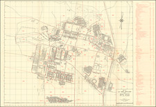
![[Indian Territory] Township No. 3 North Range No. 13 East of Indian Meridian, Indian Territory](https://storage.googleapis.com/raremaps/img/small/88866.jpg)
![[Portrait of Osage Saucy Chief]](https://storage.googleapis.com/raremaps/img/small/92655.jpg)
![(Oklahoma Territory Native American Photograph) [Cabinet card photograph of a group of eleven Native Americans, likely Pawnee or Sac & Fox, with pet dogs]](https://storage.googleapis.com/raremaps/img/small/93103.jpg)